



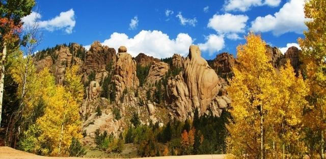
DENVER — While many species of trees change color in the fall, Colorado is perhaps most well-known for its quaking aspens, which attract residents and visitors from across the world to see golden mountainsides. Denver7 created this comprehensive guide to help you choose where to go.
Perhaps you plan to explore some trails close to Denver, like Golden Gate Canyon State Park or Conifer. Or maybe you're willing to make a day trip out to the Buena Vista area or Vail. If hiking isn't your thing, there are plenty of stunning scenic drives and train rides to enjoy, dotted with welcoming mountain communities along the way.
Whatever fits your fancy, Denver7's guide and interactive map (click the expand button in the upper right below) are ready to help with all your planning needs.
It goes without saying that this year has been a little different for the health of foliage around Colorado. Intense drought will have an impact on fall foliage colors this year as well.
John Murgel, horticulture and natural resources extension specialist with Colorado State University Extension, warned that with the drought this year, leaves on aspens are turning brown instead of yellow due to stress.
"If things are hot and dry, the tree can't pull enough water through its body to cool itself because trees cool themselves with evaporation," he explained. "And when that starts to happen, you start to see the edges of leaves scorch, and they turn brown. In a bad year like the one we just had, trees all over the place are scorching."
In spots that saw storms, foliage may put on the same brilliant displays it has for years. In places where trees were more stressed, the fall color show may be shorter than normal and may start earlier.
"Aspen trees are responding primarily to day length to go into fall color, but they'll go a lot faster if they're stressed out and strapped for resources," Murgel said. "We might see a more muted display, and it might be faster, and it might start just a hair earlier."
When deciding where to go leaf peeping this year, you may need to do a little extra research and scouting ahead of time, he said.
"Aim for those areas that have been getting some rain, because those are the areas where the trees are likely to be less stressed," he added.
Send your leaf peeping recommendations to newstips@denver7.com or post in our Discover Colorado | Through Your Photos Facebook group.

Hikes
(Always ensure the trail is open, conditions are OK and you have the layers, water and food you need before you leave home.)
Kenosha Pass (Jefferson)
Trailhead: Forest Road 849 off of US Highway 285
Length: Multiple lengths along the Colorado Trail
Drive time from Denver: 1 hour, 15 minutes
Fee: None
Notes: If you can grab a parking spot at Kenosha Pass (go early!), you can spend many miles hiking on the Colorado Trail in the glow of the yellow aspens. This is one of the most popular places to go, as you can spend hours in aspen groves. Bathrooms are available at the parking lot on the east side of the highway, but we recommend bringing toilet paper. The trail is split by the highway (the speed limit drops around the pass), so use extra caution when crossing. This spot gets very congested on weekends during peak leaf peeping season, so please drive carefully if traveling through or pulling into the parking area.

Sprague Lake Loop (Rocky Mountain National Park)
Trailhead: Sprague Lake Trailhead off Bear Lake Road
Length: About 1/2 mile, with multiple add-ons
Drive time from Denver: 2 hours
Fee: $25 daily fee, unless you have a National Parks pass. Reservations are required through Oct. 12.
Notes: This easy loop offers beautiful views of the mountains dotted in yellow aspens, all reflected on the lake. This trail is wheelchair-friendly and benches along the trail offer places to stop, rest, and take in the beauty of the Rocky Mountains. Remember, pets are prohibited on the park's trails, so leave the pup at home.
Pearl Lake Trail in Pearl Lake State Park (north of Steamboat Springs)
Trailhead: Pearl Lake State Park parking lot (61105 Rcr 129 in Clark)
Length: 3.5-mile out-and-back route
Drive time from Denver: 3 hours, 30 minutes
Fee: $10-$12 or state parks pass
Notes: Escape some of the busy spots around the Front Range to see the serene Pearl Lake. This trail starts in the state park, which comes with a fee, but then heads into the Routt National Forest. The park has 60 picnic sites to rest and take in the views.
Booth Creek Falls, Pitkin Creek Trail, Bighorn Creek Trail (Vail)
Trailhead: Just north of Interstate 70 near Vail
Length: Multiple lengths and all out-and-back trails. To get to the popular Booth Creek waterfall and back is about 4 miles and Booth Lake is about 10 miles roundtrip. Pitkin Creek Trail is about 10 miles to Pitkin Lake and back. Bighorn Creek is about 7 miles roundtrip. If you're looking for fewer people, try the latter two, though you should still expect some fellow hikers.
Drive time from Denver: 1 hour, 40 minutes
Notes: The parking lot is closed at the Booth Creek trailhead, and parking is strictly not allowed in the surrounding neighborhood, park, and school (you will be towed). The free Town of Vail bus can take you from the Vail Village parking structure to Booth Falls Road, where you will climb up the neighborhood road to the trailhead. The Pitkin Creek Trail and Bighorn Creek have their own parking lots, but they are small, so go early or on a weekday.
Golden Gate Canyon State Park (northeast of Black Hawk)
Trailhead: Multiple entry points
Length: Multiple trails
Drive time from Denver: About 45 minutes
Fee: Daily pass is $10 unless you have a state park pass
Notes: Less than an hour from Denver, this state park offers many different trails — both long and short — for visitors. Enjoy the aspens during the climbs, downhills and open fields. All trails are open yearround and dogs are welcome on a leash. Some, but not all, trails are open for mountain biking.

Ptarmigan Peak Trail (Silverthorne)
Trailhead: In Silverthorne, from Rainbow Drive, turn right onto Tanglewood Lane. Follow Tanglewood to Ptarmigan Trail Road and turn right. Follow this road for 0.8 miles to the trailhead parking on the right side of the road. The trail starts across the road from the parking area.
Length: 12 miles round trip (out-and-back trail, so it can be as long or short as you'd like)
Drive time from Denver: 1 hour, 30 minutes
Fee: None
Notes: In the fall this is a stunning place to experience the yellow aspens, but also views of the Continental Divide, Gore Range, Tenmile Range and Williams Fork Range. Keep an eye on the north ridge for an elk herd. Remember to bring layers — once you're above the trees, it can get windy. Be aware that you will cross over the burn scar from the Ptarmigan Fire in 2021.
Watrous Gulch Trail (Georgetown)
Trailhead: Herman Gulch trailhead off the Bakerville exit of I-70
Length: 5.6 out-and-back trail
Drive time from Denver: 1 hour
Fee: None
Notes: This trail takes you up through a lush green forest before leading you to aspen groves. After a couple miles, you'll start to leave the forest behind. The top can be quite steep. This trailhead is shared by hikers headed up Herman Gulch, which is a popular trail year round, so come early to grab a parking spot.

Fourth of July Trailhead/Hessie Trailhead (Nederland)
Trailhead: West of Nederland and Eldora
Length: Multiple lengths
Drive time from Denver: 1 hour, 20 min
Fee: None
Notes: While there is extremely limited parking at the Hessie Trailhead, a free shuttle from Nederland High School can bring you to the trail (leashed dogs welcome). If you plan to drive, arrive early. From the trailhead, ascend into the Indian Peaks Wilderness Area, which is filled with aspens. Keep an eye out for moose, as they are very common in this area.
Spring Creek Road and Trail (Steamboat Springs)
Trailhead: Corner of Amethyst Drive and E. Maple Street
Length: A little more than 10 miles roundtrip (it’s an out-and-back trail, so turn around early if you want to shorten the hike)
Drive time from Denver: About 2 hours, 45 minutes
Fee: None
Notes: This moderate trail starts at the intersection and heads west. It boasts beautiful wild flowers in the summer that lead to the changing aspen colors come autumn. There are some benches along the first section that are shaded if you need a break to enjoy the scenery. Park before you reach the ponds on the left. It starts as a dirt road and leads into a trail. (Bonus: If you're in the Steamboat Springs area, check out the gorgeous Flash of Gold Trail northeast of town.)
Snodgrass Mountain (Crested Butte)
Trailhead: From town, go north on Gothic Road past the Mount Crested Butte Campground until you hit the Snodgrass Trailhead on the left
Length: 2-4 miles
Drive time from Denver: 4 hours, 50 minutes
Fee: None
Notes: Visitors will be treated to yellow aspens as soon as they start this trail, with tall groves lining the beginning of the trail. In fact, Travel Crested Butte says some of the best scenery is in the first mile. This makes this route a perfect choice if you're looking for something short and don't want to summit the mountain.
Argentine Central Railroad Grade (Silver Plume)
Trailhead: Take exit 226 off I-70, look for the hiking sign and turn onto Mountain Street heading east. It ends at the trailhead. You can also start along Guanella Pass.
Length: Up to 13 miles one way
Drive time from Denver: 50 minutes
Fee: None
Notes: This trail takes users from Silver Plume toward, but not to, Grays and Torreys Peaks. It’s a long steady uphill, but is an out-and-back trail, so hikers can turn around at any point. The trail runs through many aspen groves, plus abandoned mines. Keep an ear out for the nearby Georgetown Loop Railroad.
Drives
(Note: Check to ensure the road is open before you leave home.)
Gold Camp Road
Start and end points: Colorado Springs to Victor
Drive time from Denver: 1 hour, 30 minutes
Notes: Fittingly named, the Gold Camp Road runs from west Colorado Springs to Victor. Beautiful views of the countryside and aspens will fill the curvy drive. There are plenty of places along the way to pull off the road to snap a few pictures. The road starts in Colorado Springs, but you’ll need to drive several miles west before you'll start to see aspens.
Kebler Pass
Start and end points: Crested Butte to Paonia
Drive time from Denver: 4 hours, 20 minutes
Notes: Also called Gunnison County Road 12, this road starts in Crested Butte, heads west, and ends near the south end of Paonia State Park east of Paonia. The high mountain pass takes drivers up to just over 10,000 feet, with stunning views of the landscape on both sides. This is a favorite location for leaf peeping. The pass is not paved, but it is smooth and should be fine for normal vehicles.

Gunnison County Road 3
Start and end points: South Carbondale to east of Crystal
Drive time from Denver: 4 hours, 50 minutes
Notes: Explore this road — which is a mix of pavement and dirt — by car or bike (or foot!). Also called the Road to Marble, this roadway is about 12 miles long from Evergreen Lane in south Carbondale to the split at Forest Road 317 through Marble and Crystal. Drive slowly here, especially on the rocky terrain and when passing traffic moving in the opposite direction.
Trail Ridge Road
Start and end points: Rocky Mountain National Park
Drive time from Denver: 1 hour, 45 minutes
Notes: The 48-mile Trail Ridge Road will bring you — slowly — around this national park, in full view of the changing trees. There are plenty of places to pull off and explore the wilderness on foot. Even if you choose to stay in the comfort of a car, be sure you’re hydrating because the road climbs about 4,000 feet quickly. And bring a warm jacket if you plan to get out at the top. You will need a reservation. Click here for details.
Top of the Rockies Scenic Byway
Start and end points: Copper Mountain or Minturn to Aspen
Drive time from Denver: 1 hour, 20 minutes
Notes: This byway, which hovers around 9,000 feet for several miles, has several spots along the way where you can get out to stretch your legs and explore the foliage. The byway is about 80 miles long in total and takes drivers over Tennessee Pass if you come from Minturn or Fremont Pass if you come from Copper Mountain. It continues to Twin Lakes and Independence Pass before ending at Aspen.
Peak to Peak Scenic and Historic Byway
Start and end points: Boulder to Black Hawk
Drive time from Denver: Varies, depending on point of entry
Notes: This is Colorado’s oldest scenic byway (it was established in 1918!). It winds about 60 miles though national forests along the Front Range. There are multiple spots along the way — including Rocky Mountain National Park and Golden Gate Canyon State Park — where you can get out to see more golden aspens on foot. Click here for details.

San Juan Skyway
Points along the way: Ouray, Ridgway, Telluride, Rico, Dolores, Durango, Silverton
Drive time from Denver: 5 hours, 40 minutes
Notes: This 230-mile looped byway travels through multiple southwestern towns and the San Juan and Uncompahgre National Forests. Experts recommend spending at least two days soaking in the area and scenery. Learn more here.
Guanella Pass Scenic Byway
Start and end points: Georgetown to Grant
Drive time from Denver: 50 minutes
Notes: If you’re itching to see the changing aspens without a lengthy road trip, Guanella Pass is your go-to. Just be ready for traffic. The leaves usually start changing here earlier than other places in the central Rockies. If you want to stretch your legs, you can hop out to walk on the Bierstadt Trail (or go all the way to the summit at 14,065 feet for more breath-taking views). As with all high-elevation spots, weather can change quickly here, so keep an eye on the sky. Click here for more.

West Elk Loop
Points along the way: Paonia, Gunnison, Crested Butte and Carbondale
Drive time from Denver: 3 hours
Notes: Take a couple days — or one, if you're OK with driving 6-8 hours — and explore this loop, which spans more than 200 miles. See the Crystal River, Mount Sopris and Black Canyon of the Gunnison. While enjoying the yellow aspens, you can also check out the area's rich mining history. Kebler Pass, which is along this route, closes for the season in November. Click here for more.
Cottonwood Pass along County Road 306 between Buena Vista and Taylor Park
Start and end points: Buena Vista to Almont
Drive time from Denver: 2 hours, 45 minutes
Notes: Drive over the Continental Divide and enjoy the changing aspens on the way up and down, while taking in an incredible mountain pass at 12,126 feet in the middle. The pass is paved, so most cars should be able to make it to the top just fine. In fact, Cottonwood Pass is the highest paved mountain route over the Continental Divide. Camping is available in the area. Cyclists often use this route, so remember to share the road.
Train rides
(Prices vary for each ride depending on time of year and type of service.)
Georgetown Loop Railroad
Start and end locations: Georgetown and Silver Plume
Notes: This railroad has a Fall Colors tour geared toward leaf peeping in September and October. Visitors will stay in open air cars for the majority of the season. The company says that Uber and Lyft rarely operate between Denver and Georgetown. Coach cars do not offer snacks or beverage service. The loop is about 1 hour and 15 minutes for the main season and about 55 minutes from mid-October through early January.
Leadville Colorado & Southern Railroad
Start and end locations: Leadville and Climax
Notes: Take a trip around the Continental Divide and San Isabel National Forest. Roundtrips are about 2.5 hours long. Fall Specials trips are offered on weekends in September departing the depot at 10 a.m. and/or 2 p.m., depending on the day. Remember to bring a jacket as temperatures will likely get chilly. Seasonal beverages and snacks are available for purchase.
Cripple Creek and Victor Narrow Gauge Railroad (season will end the first weekend of October)
Start and end locations: Cripple Creek and Victor
Notes: This ride, which is narrated with information on the area, takes visitors four miles in 45 minutes, including stops along the way. It leaves every 70 minutes between 10 a.m. and 5 p.m. This is first come, first served, so no reservations are needed. The cars are open so dress for rain or shine (a jacket is a must).
Durango and Silverton Train
Start and end locations: Silverton and Durango
Notes: Take a ride on this historic train through the mountains and canyons around Durango and Silverton and soak in the fall foliage along the way. You can take the Scenic Round Trip Silverton Train which lasts 3.5 hours each way, plus a two-hour layover in Silverton. If you're seeking an experience away from cell service and deep in the rugged wilderness, this ride is for you.
Cumbreas & Toltec Scenic Railroad
Start and end locations: Antonito, Colorado to Chama, New Mexico
Notes: Over the course of 64 miles, the Cumbres & Toltec Scenic Railroad is a National Historic Landmark and the longest, highest steam railroad in North America. This train runs six days a week (Tuesday-Sunday) until Oct. 25. If you want a train ride specifically catered toward the changing leaves, look into hopping aboard this railroad’s autumn adventures ride.
