


DENVER — Xcel Energy is preparing for power impacts across the Front Range foothills as hurricane-strong winds and dry conditions lead to increasing wildfire danger through the remainder of the week.
“Despite the recent snowfall, dry fuels persist, coupled with high winds and historically low snowpack,” an Xcel spokesperson said in an email Monday announcing how the energy company was preparing ahead of critical fire weather conditions for the Front Range mountains and foothills.
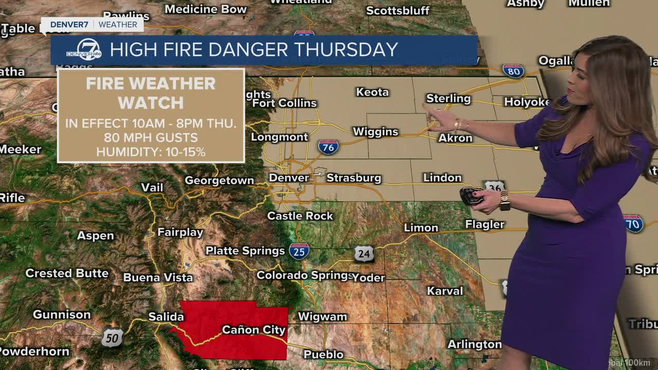
A high wind warning has already been issued for the Front Range mountains and the northern foothills from 4 a.m. Thursday through noon Friday. The warning starts at 10 a.m. and goes though 7 p.m. Thursday for the adjacent plains west of Interstate 25 and near the Wyoming border, according to the National Weather Service in Boulder.
Westerly winds between 35-50 mph with gusts up to 75 mph are expected. Forecasters said areas north of Wellington could see up to 80 mph wind gusts and the foothills and the higher Front Range mountains can expect gusts of up to 90 mph Thursday.
A high wind watch will also be in effect all of Thursday in Boulder and the western suburbs of Denver, NWS officials said.
At the same time, a red flag warning will also be in effect for the plains and the Palmer Divide from 11 a.m. to 9 p.m. Thursday as gusts of up to 80 mph descend near the base of the foothills and 40-60 mph gusts blow through the plains. Those high winds, coupled with humidity values down to the teens could lead to rapid wildfire spread, according to the NWS.

Greg Heavener, a warning coordination meteorologist for the NWS in Boulder, said during a virtual call Tuesday and Wednesday that both Thursday and Saturday look to have the strongest wind events.
On Thursday, winds will start to pick up through the morning before gradually increasing and peaking at around noon, said NWS meteorologist Kenley Bonner.
Areas along and west of I-25 north of Wellington all the way up to the Wyoming border could see some pretty strong crosswinds, with 75-80 mph wind gusts for areas around Estes Park and 70-75 mph wind gusts for Red Feather Lakes, he said.
Though the forecast calls for peak wind gusts between 50-55 mph west of Boulder, forecasters were still uncertain as to how far east the strongest winds will be.
“The biggest question is, how far east do the winds on Thursday make it?” Heavener said, adding the lowest foothills and plains would be most vulnerable to critical fire weather conditions.
While the main areas of uncertainty remain around Fort Collins north to the Wyoming border, southern Larimer County all the way down to Douglas County, and areas west of I-25 in Boulder and Jefferson counties, Heavener said weather service officials were seeing “more refinement” that the strongest winds (those with 80+ mph wind gusts) will stay west of Highway 93 for Thursday’s wind event.
“We do think that the gusts that do come off the foothills will be less frequent than they will be in the foothills,” Heavener said Tuesday.
Looking at Friday, windy conditions will still be high for the higher elevations and won't reach as far east as Thursday, but humidity values will still be in the low to upper teens for much of the foothills and plains, meteorologists said.
"Saturday is not looking very good," Bonner said. Though winds won't be as strong as Thursday, "they're going to be more widespread." Those winds, coupled with low humidity values in the Denver metro, could lead to critical fire weather conditions.

Xcel Energy officials said they will likely activate Enhanced Power Safety Settings (EPSS) in lieu of power safety power shuts offs, which have been scrutinized by lawmakers following backlash from impacted communities.
In December, more than 86,000 people in Boulder were without power following planned power outages which took days to restore. And in January, more than 9,000 people were impacted in Larimer and Weld counties. Those latter shutoffs forced several schools to cancel classes.
Xcel officials said the EPSS allow power lines to remain active until an issue is detected such as “a tree branch or other object touching” a line.
How people can prepare ahead of a potential power shutoff
The first thing people should do is stay up-to-date by going to Xcel’s website ahead of Friday’s high fire danger event. Xcel customers should also make sure their account information and communications preferences are up to date in their Xcel accounts, and should check the status of an outage by going to Xcel’s statewide Outage Map, which can notify people when outages may be resolved.
Xcel Energy also provided a list of recommended items for a home emergency kit:
- Battery-powered radio
- Flashlights
- Batteries
- Backup phone chargers
- Phone that does not require electricity
- Non-electric alarm clock
- Bottled water and non-perishable food
- Manual can opener
- First-Aid kit
- Extension cords
Xcel Energy officials said customers with medical equipment that requires electricity should take steps to prepare backup power should outages occur, adding Colorado residents with qualifying medical conditions will be contacted by the utility company about these expected power impacts.