


DENVER – An “impactful winter storm” will move into the Denver metro by Tuesday evening, bringing considerable snow to the area and greatly impacting travel along the I-25 corridor through Wednesday afternoon, according to forecasters with the National Weather Service (NWS) in Boulder.
The latest storm system has already started making its way through the San Juans and southern valleys of Colorado with a lull in snowfall happening between now and early Tuesday morning.
One to two feet of new snow are "not out of the question" for the San Juan mountains and another 6 to 10 inches of snow for the southern valleys are possible when all is said and done, NWS officials in Grand Junction said Monday morning.
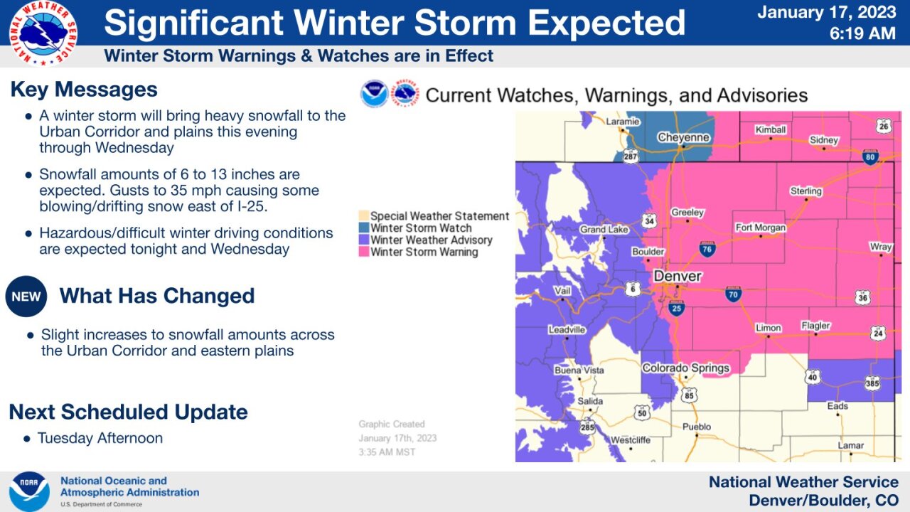
Winter weather advisories will be in effect from 11 a.m. Tuesday through 5 p.m. Wednesday for the Gore and Elk mountains as well as the central mountain valleys, and will affect cities like Aspen, Vail, Snowmass, Ridgway, Glade Park, Telluride, Ouray and Lake City.
Those in the mountains are advised to plan on slippery road conditions as travel could be very difficult due to patchy blowing snow which could “significantly reduce visibility,” especially on ridge tops and mountain passes, forecasters said.
That system will make it to the I-25 corridor by late Tuesday afternoon, though forecasters do not anticipate snow beginning until between 6 to 8 p.m. — and because of the sunny skies today, roads should be fine for a while before slick conditions begin closer to 7 or 8 p.m.
"In other words, most of the evening commute today should be in good shape, although the tail end of it may see impacts," NWS forecasters said.
A winter storm warning along the I-25 corridor, covering an area from Fort Collins down to just north of Colorado Springs and expanding eastward to the Nebraska-Kansas state border will be in effect from 5 p.m. Tuesday through 5 p.m. Wednesday, according to the NWS.
The storm system is expected to bring heavy snow Tuesday night into Wednesday morning across portions of eastern Colorado, dumping between six to 13 inches of snow across the I-25 corridor with the potential for as much as nine to 14 inches of snow east of I-25 across the far northeast plains. Winds could reach gusts as high as 35 mph east of I-25 and along I-76 and eastern I-70 with some blowing and drifting snow possible, NWS forecasters warned.
At a virtual news conference Monday afternoon, Greg Heavener with NOAA said Denver's forecast ranged from three to 11 inches, putting a 9/10 chance the area will see more than three inches of snow and a 1/10 chance it will see more than 11 inches.
How will travel be impacted?
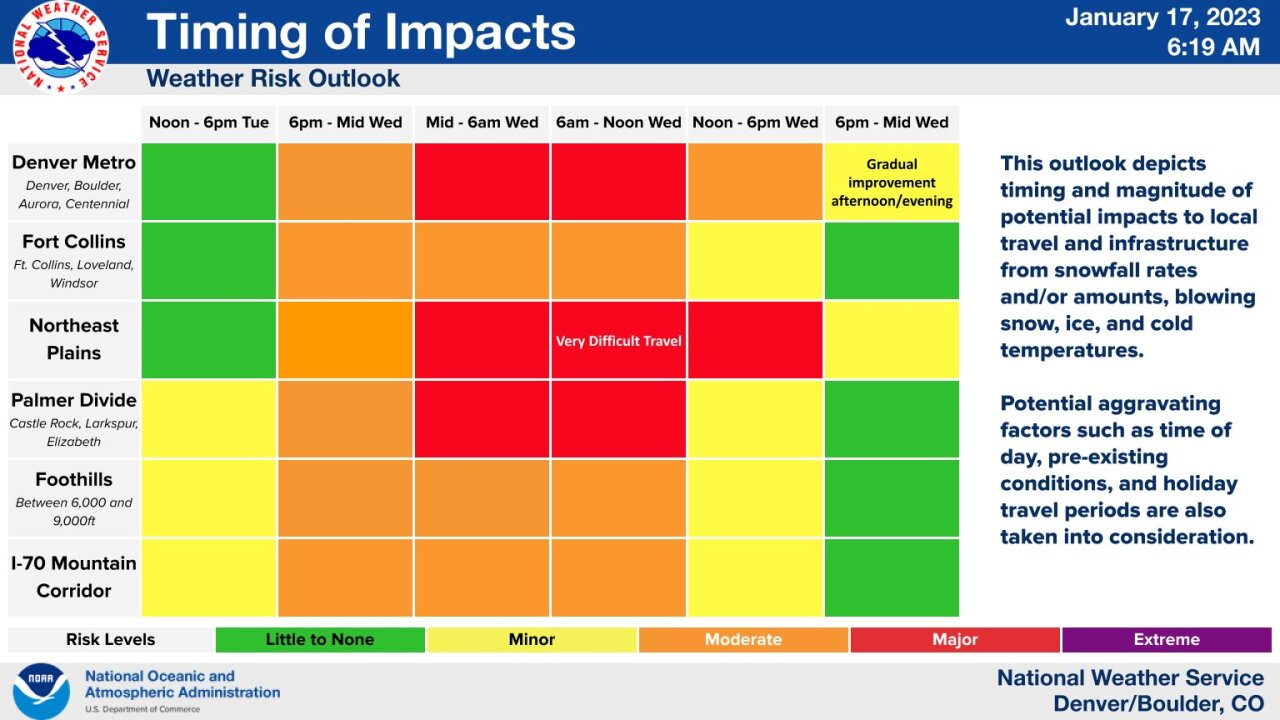
Those traveling through the mountains on Tuesday and Wednesday should start making plans as hazardous travel is expected for the Tuesday evening and Wednesday morning commutes, the NWS said, though impacts could last well into the late hours of Wednesday.
For the metro, travel conditions will start deteriorating at the tail end of the Tuesday evening commute and will become treacherous not just for the Denver area but for Fort Collins, the northeast plains, the Palmer Divide and the Foothills overnight, greatly impacting the Wednesday morning commute as the heaviest snowfall will begin around midnight Tuesday and continue through Wednesday at noon, both Heavener and NWS officials said.
"Significant impacts can be expected, and the Wednesday morning commute in particular will be treacherous," forecasters warned, while advising people who are able to work from home Wednesday morning to do so to avoid dangerous road conditions. "If you can avoid it, it will be best to avoid travel."
If you must travel, the NWS advises that you keep an emergency kit in your vehicle and check road conditions by calling 511.
The statewide snowfall will come to an end late Wednesday and Heavener said things will start to dry out along the northern I-25 corridor by the afternoon and evening. Additional accumulations of one to three inches of snow across the I-25 corridor, and two to five inches for most of the northeastern plains are possible once the storm moves east, NWS officials said.
Another system will try to shift into our region by the end of the work week, passing across the area late Friday or early Saturday with a chance for some light snow, according to the latest forecast discussion.
Temperatures will remain in the 30s for the rest of this week and the weekend should be mostly quiet, but NWS forecasters said another potential storm is arriving near the start of next week.