


DENVER – Heavy snowfall and wind-driven snow will create “difficult to impossible” travel conditions for those heading to the mountains this weekend, according to forecasters with the National Weather Service.
Though snow is already falling west of the Continental Divide, conditions will deteriorate by the afternoon with moderate to heavy snowfall increasing over the northern and north central mountains by nightfall.
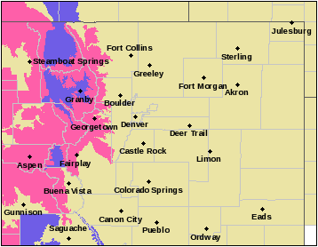
Winter storm warnings have been issued for the mountain ranges surrounding Steamboat Springs, Granby, Georgetown, Fairplay, Aspen, Buena Vista and Gunnison, while a winter weather advisory is in effect east of Steamboat Springs, west of Granby, west of Fairplay and south of Gunnison. Both are set to expire at 11 p.m. Saturday.
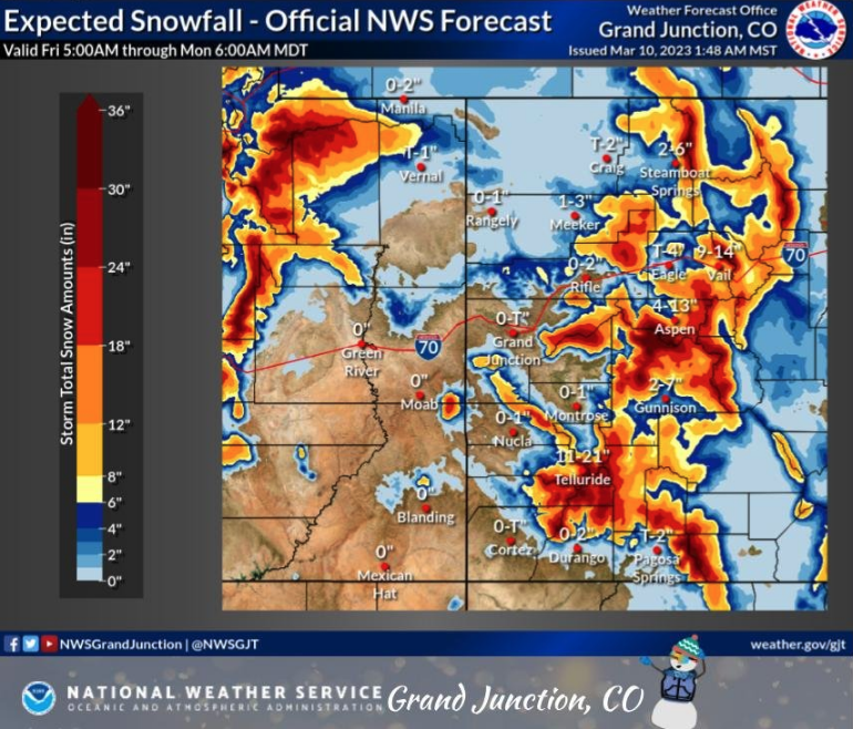
These areas should expect between 3 to 21 inches of heavy, wet snow with some bands exceeding rates of 1 to 2 inches per hour along with wind gusts ranging from 35 to 60 mph, according to NWS forecasters. Considerable blowing snow is expected to occur over the passes.
Road conditions will be icy and snow-packed, and the wind gusts will create blowing snow and poor visibility at times, forecasters said.
“Needless to say, expect travel conditions to become difficult, if not impossible by this evening and overnight due to heavy snow and blowing snow, particularly over mountain passes,” National Weather Service forecasters in the Grand Junction region said in their latest discussion.
The Colorado Department of Transportation (CDOT) has already warned drivers of “treacherous winter driving conditions this weekend,” and is urging those heading to the mountains including skiers, backcountry users and spring break travelers, to plan ahead.
The highway mountain passes and the I-70 corridor will see “severe impacts with heavy snowfall and wind-driven snow” which will cause slushy roads, snow-packed conditions and potential white-outs, according to state transportation officials.
John Lorme, CDOT’s director of maintenance and operations, recommends that Coloradans and tourists alike be prepared with more than just their outdoor gear this weekend and to pack in extra food, water, warm clothes, blankets and a first-aid kit as “safety closures may happen at any time during severe weather and if you are held up on the highway you want to be prepared.”
RELATED: How to prepare your car for Colorado’s winter weather
“If you do not have experience driving in winter weather, please avoid driving in the mountains this weekend,” CDOT officials said in a news release Thursday. “We understand that many folks may be visiting Colorado this weekend and urge them to consider taking CDOT’s Pegasus, Snowstang or Bustang to get to their destinations safely.”
Those traveling to the mountains were also urged to check out the latest conditions and to visit COtrip.org to see how roads are being impacted before heading out the door. Officials also reminded drivers to take it slow, avoid sudden stops and leave plenty of following distance once you’re on the road.
The Colorado Avalanche Information Center posted an avalanche watch across much of western Colorado’s mountain ranges, warning of “very dangerous avalanche conditions” developing by midday Saturday and continuing through Sunday.
Snow will linger in the mountains Sunday with highs in the upper 20s.