


DENVER – If you’ve been in Colorado for at least the last two winters or so, you’ve likely come across someone mentioning how much we need the moisture if you dared mention how much snow we’ve been getting this season.
Both arguments, contrary as they may be, are not actually wrong – and data, both historical and current, proves they’re both right.
You may not know this (or you may have forgotten already), but Colorado was really dry at this time last year. In fact, about 83% of the state was considered to be in a moderate drought. Right now? That number is way down – just 36% of the state is considered to be experiencing moderate drought, according to the latest U.S. Drought Monitor report.
Satellite imagery from the National Weather Service Colorado Basin River Forecast Center also shows just how much our snowpack situation has improved.
Last year on March 27th we were breaking temperature records with a high of 79 at the SLC airport. This year we are breaking snowpack records across parts of the #ColoradoRiver basin. It's pretty incredible to see the difference between the two years. #utwx #cowx #azwx pic.twitter.com/9Ph39KuVKO
— Colorado Basin RFC (@nwscbrfc) March 27, 2023
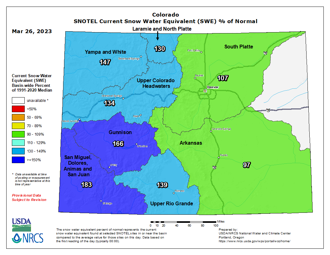
So much has our snowpack improved? As of 12 a.m. Monday, Colorado’s snowpack was 141% of median, according to the U.S. Department of Agriculture’s Natural Resources Conservation Service website.
You can see that pretty much everything west of the Continental Divide is doing pretty well for itself when compared to a year ago.
The snowfall Colorado’s high country has been getting for the past several months has, without a doubt, helped get Colorado to a point where nearly half of the state (46.56%) is drought-free.
During a recent climate conversation with CPR’s Ryan Warner, Denver7 chief meteorologist Mike Nelson said the statewide snowpack is “very good right now,” with some areas in southwest Colorado at almost 200% of normal, “which is great news,” he said.
The San Miguel, Dolores, Animas and San Juan basin leads the pack at 183% of normal – a 43% increase in its snow water equivalent since the beginning of the month.
The Gunnison basin follows at 166% of normal; the Yampa and White basins come third with 147% of normal, then the Upper Rio Grande follows at 139% of normal, with the Upper Colorado Headwaters basin at 134%; the Laramie and North Platte basin clocks in at 130% of normal; and the South Platte and Arkansas basins come in last, at 107% and 97% of normal, respectively.
And the most recent snowfall in the mountains will help conditions in those areas, though we still do not know exactly how much conditions will improve as data takes several days to show up following a recent snowstorm.
What we can tell you though, is that we had some impressive snow totals come in from that storm:
Pierce, northeast of Fort Collins, registered more than a foot of snow (13.5 inches), with areas about a mile from near Sterling and Windsor recording nearly a foot (11 inches).
Areas north-northeast of Fort Collins saw close 10 inches of snow, while places like Sterling saw 8 inches. East of Loveland, residents reported a little more than 6 inches of snow while Aspen Springs, for example, only registered about 4 inches of snow from this latest snowstorm.
Here in the metro there was not that much action. Denver, for example, only recorded just a little more than an inch of fresh powder.
What will our impressive snowpack conditions mean for the spring and summer here in Colorado?
“It does open up the concern about the snowmelt flooding in the spring when the warm temperatures really start to bring that snow down in a hurry,” Nelson said.
