DENVER — A flash flood warning has been issued for the Denver metro area as thunderstorms dumped very heavy rain over the Metro area.
MORE | Live interactive radar| Weather page | Traffic conditions
WEATHER BLOG:
Below you can find live updates on weather and traffic conditions, along with photos and videos of the storm as it moves through Colorado:
9:34 p.m. | There's a safety closure on the on-ramp to I-25 on Colfax Ave. due to flooding, CDOT says.
8:09 p.m. | A car is stalled due to flooding at MLK Blvd. and Monaco Parkway. Avoid the area.
One car stalled at MLK & Monaco St Pkwy. Avoid this area #dontriskit pic.twitter.com/yNsLAZAj4e
— Jessica Porter (@JessicaDenver7) August 22, 2019
7:33 p.m. | Aurora is now off accident alert status.
7:02 p.m. | Aurora is on accident alert because of the severe weather.
Flash Flood Warning in Aurora. We are on #AccidentAlert at this time due to weather & high volume of calls for service. Submit accident reports at https://t.co/Few6y1rOBT unless injury, hit and run or DUI related in which you should call 911. https://t.co/1bspBLsCsf
— Aurora Police Dept (@AuroraPD) August 22, 2019
6:54 p.m. | 17th and Humboldt is experiencing street flooding.
#Developing: Flash flood warning issued for metro-Denver. This is street flooding right now at 17th & Humboldt in Uptown. #cowx @DenverChannel @MikeNelson247 pic.twitter.com/cRJ441MhMt
— Russell Haythorn (@RussellHaythorn) August 22, 2019
6:51 p.m. | Several streets in the area are seeing flooding.
It’s flooding pretty bad in certain spots of the Capitol Hill neighborhood of #Denver. pic.twitter.com/Z2rOam7Gi0
— James Dougherty (@DoughertyKMGH) August 22, 2019
6:41 p.m. | A flash flood warnng has been issued for the Denver metro area.
Storms are expected to move east of the area by midnight. Expect low clouds over the Front Range and plains early, with hazy sunshine through mid-morning. Lows will drop to the upper 50s and low 60s.
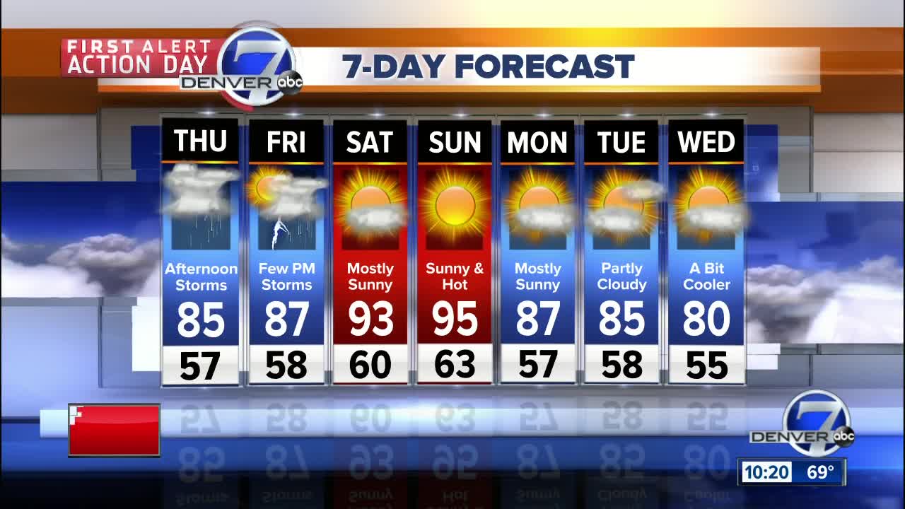
The Front Range and plains will likely see scattered storms again on Thursday afternoon. Temperatures will be in the mid to upper 80s for highs in Denver. Expect dry conditions to start, with increasing clouds through the day, followed by storms and showers into the late afternoon and early evening. There will be a lower risk for severe weather tomorrow.
Hotter and drier weather will again return to most of Colorado for the weekend. Highs will be in the mid-90s in the Denver area on Saturday and Sunday. In the mountains, highs will be in the upper 70s to middle 80s.
Cooler and rather pleasant weather can be expected early next week - perhaps a little taste of Autumn!


