Denver7 | WeatherToday's Forecast

Actions

Snow continues across Colorado through the Wednesday morning commute

More than a foot of heavy, wet snow for the northern Front Range mountains before sunshine later in the afternoon
Snow continues across Colorado through the Wednesday morning commute
Lisa am wx 5-6-26.jpg
Posted
and last updated

DENVER — Happy snow day Colorado! A major spring storm continues to roll through the region and we've already seen more than a foot of snow across parts of the Colorado high country.

LISA AM WX.jpg

A winter storm warning is in effect until 3 p.m. and includes Denver, Boulder, Fort Collins, Castle Rock and surrounding areas, including the western suburbs.

We'll likely see an additional 1 to 3 inches for the core of the metro area, with another 3 to 5 inches in the mountains and foothills. This heavy, wet snow is breaking branches and causing some power outages across the city. Be sure to shake your trees off when you wake up this morning!

  • Watch the full forecast in the video player below.
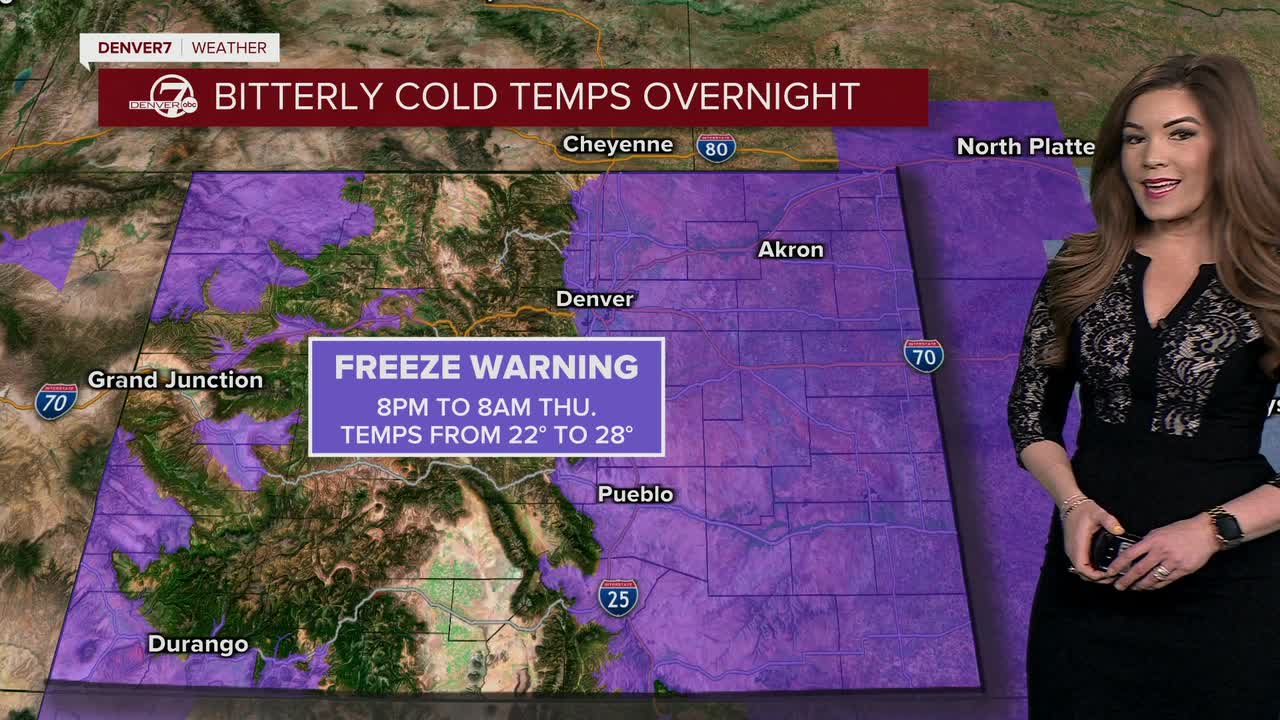
Snow continues across Colorado through the Wednesday morning commute

It looks like this storm will bring between 4 and 8 inches of snow around the city with 5 to 10 inches in Fort Collins, Boulder and south toward Castle Rock and the Palmer Divide. Some areas near the foothills could easily end up with up to 12 inches of heavy, wet spring snow by Wednesday afternoon.

The roads will be wet and slushy across the metro area, with more snowpacked conditions out west.

Traveling could become difficult, if not dangerous, north of Interstate 70 along the higher mountain passes as we're expecting significant heavy snow in those locations.

Areas north of I-70 could see 14 to 24 inches of new snow with some areas receiving up to 30 inches above 9,000 feet. Winter Park, Breckenridge and the Eisenhower/Johnson Tunnels could get 6 to 16 inches of snow by Wednesday afternoon.

Skies will gradually clear out this afternoon, with sunshine for the evening commute! As skies clear, temperatures will tank. A freeze warning will go into effect 8 p.m. Wednesday through 8 a.m. Thursday for the Interstate 25 corridor and Eastern Plains for lows dipping into the low 20s, bringing a hard freeze to the area. Protect your plants and pipes!

Temperatures rebound into the mid to upper 60s Thursday under mostly sunny skies. We'll see lots of melting along the Front Range as highs top off in the low 70s Friday.

So far, it looks like the mild weather sticks around through the weekend with a few passing showers. Heading into next week, the spring heat moves in with highs in the 80s on Monday and Tuesday.

DENVER WEATHER LINKS: Hourly forecast | Radars | Traffic | Weather Page | 24/7 Weather Stream

Click here to watch the Denver7 live weather stream.

Denver7 live 24/7 weather stream