


DENVER — It wouldn’t be Colorado if we didn’t have critical fire danger conditions followed by heavy snow just a day later. But that’s exactly the scenario that will play out across parts of the state as we head into the tail end of the work week.
Warm and dry conditions were felt Thursday across the Denver metro as temperatures reached the upper 60s to low 70s. Windy conditions along and south of I-70 also gave way to high fire danger, with unseasonably warm temperatures in the 70s and near 80 degrees in far southeast Colorado.
Those winds, along low humidity values, prompted the National Weather Service in Boulder to issue another red flag warning from Castle Rock all the way down south the New Mexico border until 6 p.m. Thursday.
But in true Colorado fashion, weather conditions will drastically change late Thursday night into Friday, when a powerful winter storm swings into Colorado, ushering in heavy mountain snow that will then spread across the plains Friday.
What’s going to happen in the mountains?
A winter weather advisory will go into effect for the next 24 hours starting midnight Thursday for the High Mountain Parks, the Front Range Foothills, the Park Range mountains, and the Palmer Divide. Between 3 inches and up to a foot of snow are forecast for the area, with the heaviest amounts falling in the southern foothills.
The northern and southern Front Range foothills, as well as Castle Rock, Elizabeth, and Larkspur will be under a winter weather advisory for about 24 hours starting midnight Thursday. Total snow accumulations for these areas could be anywhere between 3 inches and a foot of snow, according to the National Weather Service.
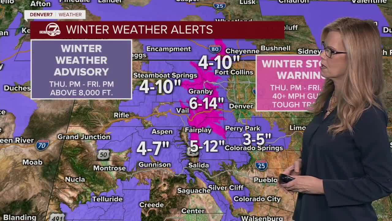
The biggest impacts from this snowstorm, however, will be felt across the Front Range mountains, the Medicine Bow Range, the mountains of Summit County and the Mosquito Range.
A winter storm warning will be in effect midnight Thursday through midnight Friday for those areas due to gusty winds reaching 40 mph. Blowing and drifting snow along the higher mountain passes will make for extremely treacherous driving conditions. The NWS said Thursday they expect between 6 and 15 inches of snow to fall along these areas.
Weather service officials said localized snowfall rates of 1-2 inches per hour can be expected under the heaviest showers/snow bands, “most likely along and south of the I-70 mountain/foothills corridor, and across the Palmer Divide.”
Those traveling to the mountains or foothills will encounter a tough morning commute Friday, with evening ski travel also particularly impacted by the evening, according to the NWS.
How much snow can we expect in the Denver metro?
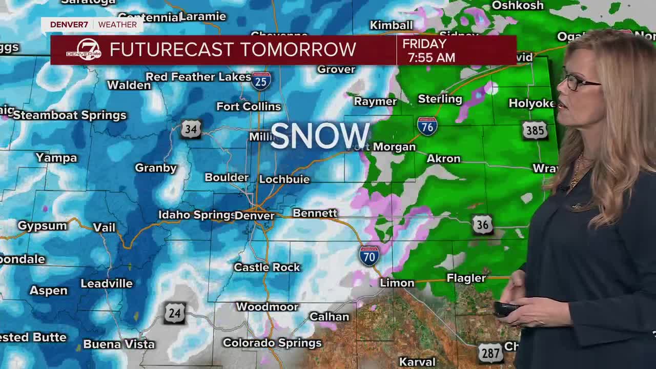
So far, it looks like it’ll be a slushy and snowy Friday for the Denver metro area, according to Denver7 chief meteorologist Lisa Hidalgo.
The shift will begin late Thursday night when the cold front moves over into the plains, bringing temperatures down to near freezing by sunrise.
NWS officials said a few rain/snow showers are possible overnight for the urban corridor, mainly north of Denver, “but almost all of the snow will hold off until after daybreak Friday.”
“Friday morning will see the bulk of the impacts as steady snow develops across the I-25 corridor and becomes heavier in our mountains and foothills,” they wrote in Thursday’s forecast discussion.
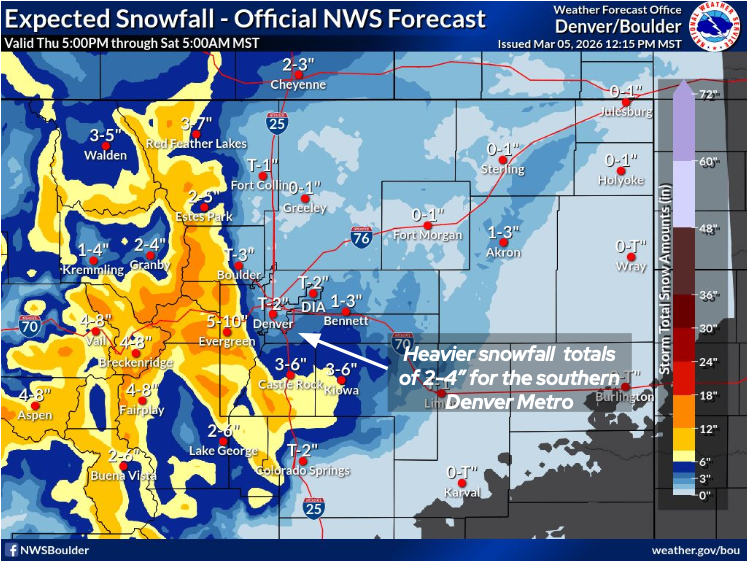
Between a trace to 2 inches of snow are expected for Denver, with heavier snowfall totals south and west of the metro, according to the NWS.
"Overall, it looks like light amounts of snowfall ... should be pretty slushy here for our area; it's just been so warm lately," said Denver7 meteorologist Stacey Donaldson. "If you are skiing in the next couple of days, some great powder on the way."
Friday’s snowstorm will break Denver’s long spell of unseasonably warm temperatures this winter. The last time the Mile High City had any measurable snowfall was on Jan. 25.
Check latest Colorado winter weather alerts
“Commuters should prepare for slick conditions in the morning regardless,” forecasters wrote Thursday, adding northern portions of the I-25 corridor will be less favored.
The plains will also see limited accumulations as temperatures hovering in the mid to upper 30s, “despite a likely band of greater precipitation extending northeast from the Palmer Divide into the Morgan, Washington and Logan county lines, forecasters said.
Highs on Friday for the I-25 corridor will be in the mid to upper 30s, with temps below freezing in the high country.
Milder and drier weather will return Saturday with a high of 50, and the warming trend continues through Monday, with a high for Denver of 71 degrees.
Colorado snow totals
Here are possible “expected” and “high-end” snow totals across Colorado and the Denver metro area from the NWS.
- Agate, CO – 2" - 3"
- Akron, CO – 2" - 3"
- Allenspark, CO – 9" - 11"
- Alma, CO – 9" - 11"
- Amherst, CO – 0.5" - 1"
- Antero Reservoir, CO – 4" - 7"
- Arvada, CO – 2" - 4"
- Aurora, CO – 2" - 4"
- Bailey, CO – 7" - 9"
- Bear Lake, CO – 8" - 12"
- Bennett, CO – 3" - 4"
- Berthoud Pass, CO – 13" - 16"
- Berthoud, CO – 1" - 2"
- Black Hawk, CO – 9" - 11"
- Boulder, CO – 3" - 5"
- Breckenridge, CO – 9" - 11"
- Briggsdale, CO – 1" - 1"
- Brighton, CO – 1" - 2"
- Broomfield, CO – 1" - 4"
- Brush, CO – 0.5" - 1"
- Buckthorn Mountain, CO – 5" - 7"
- Byers, CO – 2" - 2"
- Cameron Pass, CO – 9" - 11"
- Carr, CO – 1" - 2"
- Castle Rock, CO – 5" - 7"
- Centennial, CO – 3" - 4"
- Central City, CO – 9" - 11"
- Coal Creek Canyon, CO – 13" - 16"
- Commerce City, CO – 1" - 3"
- Conifer, CO – 12" - 14"
- Cooper Mountain, CO – 10" - 13"
- Cope, CO – Trace" - 1"
- Crook, CO – 0.5" - 1"
- Deckers, CO – 5" - 6"
- Deer Trail, CO – 2" - 3"
- Denver, CO – 1" - 3"
- DIA – 2" - 3"
- Dillon, CO – 7" - 8"
- East Portal, CO – 15" - 18"
- Echo Lake, CO – 14" - 17"
- EJM Tunnel, CO – 12" - 15"
- Elbert, CO – 6" - 7"
- Eldora, CO – 12" - 14"
- Elizabeth, CO – 6" - 7"
- Erie, CO – 1" - 3"
- Estes Park, CO – 4" - 5"
- Evergreen, CO – 9" - 10"
- Fairplay, CO – 7" - 9"
- Fleming, CO – 2" - 3"
- Floyd Hill, CO – 9" - 11"
- Fort Collins, CO – 1" - 2"
- Fort Lupton, CO – 1" - 2"
- Fort Morgan, CO – 0.5" - 1"
- Franktown, CO – 5" - 6"
- Fraser, CO – 7" - 10"
- Fremont Pass, CO – 10" - 13"
- Frisco, CO – 6" - 9"
- Georgetown, CO – 10" - 12"
- Golden, CO – 5" - 6"
- Gould, CO – 6" - 8"
- Granby, CO – 3" - 6"
- Grand Lake, CO – 3" - 7"
- Grant, CO – 8" - 10"
- Greeley, CO – 1" - 2"
- Grover, CO – 1" - 2"
- Guffey, CO – 5" - 10"
- Haxtun, CO – 1" - 2"
- Heeney, CO – 8" - 9"
- Highlands Ranch, CO – 3" - 5"
- Holyoke, CO – 0.5" - 1"
- Hoosier Pass, CO – 12" - 14"
- Hot Sulphur Springs, CO – 3" - 7"
- Hoyt, CO – 1" - 2"
- Hugo, CO – Trace" - 1"
- Idaho Springs, CO – 8" - 9"
- Johnstown, CO – 1" - 1"
- Julesburg, CO – 0.5" - 1"
- Karval, CO – Trace" - 0.5"
- Kenosha Pass, CO – 6" - 9"
- Keystone Ski Area Summit, CO – 10" - 12"
- Kiowa, CO – 5" - 7"
- Kremmling, CO – 2" - 5"
- Kutch, CO – 0.5" - 1"
- Lafayette, CO – 1" - 3"
- Lake George, CO – 4" - 8"
- Lakewood, CO – 3" - 5"
- Larkspur, CO – 8" - 10"
- Limon, CO – 1" - 2"
- Lindon, CO – 1" - 3"
- Littleton, CO – 3" - 3"
- Longmont, CO – 1" - 2"
- Loveland Pass, CO – 12" - 14"
- Loveland, CO – 1" - 1"
- Lyons, CO – 2" - 4"
- Matheson, CO – 1" - 3"
- Milner Pass, CO – 9" - 10"
- Monument Hill, CO – 8" - 10"
- Mt. Zirkel, CO – 5" - 9"
- Muddy Pass, CO – 7" - 9"
- Nederland, CO – 9" - 11"
- New Raymer, CO – 1" - 1"
- Northglenn, CO – 1" - 3"
- Nunn, CO – 1" - 1"
- Parker, CO – 4" - 5"
- Peetz, CO – 1" - 2"
- Rabbit Ears, CO – 8" - 10"
- Rand, CO – 6" - 7"
- Red Feather Lakes, CO – 5" - 8"
- Roach Snotel, CO – 9" - 12"
- Roggen, CO – 1" - 2"
- Rollinsville, CO – 10" - 12"
- Roxborough Park, CO – 5" - 7"
- Sedgwick, CO – 0.5" - 1"
- Shamrock, CO – 1" - 2"
- Spicer, CO – 6" - 8"
- Sterling, CO – 0.5" - 1"
- Superior, CO – 2" - 5"
- Vail Pass, CO – 10" - 12"
- Vail, CO – 6" - 10"
- Virginia Dale, CO – 3" - 7"
- Walden, CO – 4" - 6"
- Wellington, CO – 1" - 1"
- Willow Creek Pass, CO – 9" - 11"
Here are links to cold weather shelter information and other resources for Denver metro communities.
- Arapahoe County
- Arvada
- Commerce City
- Denver
- Douglas County
- Fort Collins
- Jefferson County
- Littleton
- Lakewood
- Longmont
- Westminster
The City of Denver has activated its cold weather shelter plan.
"All shelter sites are pet-friendly and provide food, showers, and blankets. Transportation will run daily from downtown shelters to cold weather shelter sites. Security will be present at each site, and shelters will deactivate once weather improves," wrote the city in a news release.
Here's additional information from the city on places to find shelter:
- For individual men – Denver Rescue Mission Lawrence Street Community Center, 2222 Lawrence St.
- For individual women – Samaritan House, 2301 Lawrence St.
- For youth/young adults ages 12-24 – Urban Peak, 1630 S. Acoma St.
- For families - Inn at the Highland, 2601 Zuni St. For additional support or questions contact the Connection Center at 303-295-3366.
- 24/7 shelter is being provided at 2601 W. 7th Ave., 375 S. Zuni St., and 4411 Peoria St.
- Additional shelter is now being provided at 4849 Bannock St, and The Aspen shelter at 4040 Quebec St. will open today at 1 p.m.
DENVER WEATHER LINKS: Hourly forecast | Radars | Traffic | Weather Page | 24/7 Weather Stream

Click here to watch the Denver7 live weather stream.