


GRAND JUNCTION, Colo. — The mountains of Colorado's Western Slope will see one to two feet of snow — or more in some areas — as atmospheric river moisture moves east from Southern California.
The storm on the west coast hit over the weekend and set records, with between 5 and 10 inches of rain falling over the Los Angeles area, according to the Associated Press. The yearly average for the area is 14.25 inches.
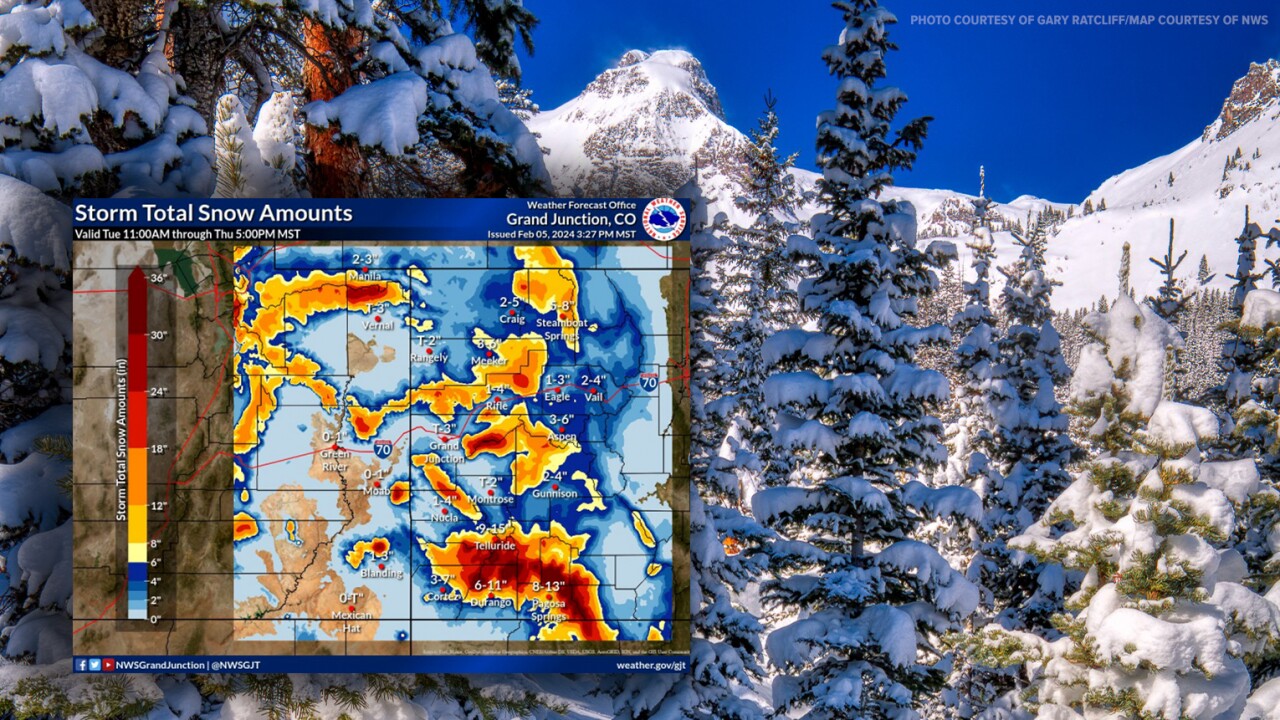
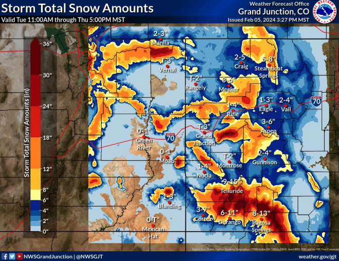
The National Weather Service (NWS) out of Grand Junction said widespread moderate to heavy moisture will move over western, particularly southwestern, Colorado on Tuesday afternoon through Wednesday. But this storm, which the NWS called "anomalous moisture," will likely bring heavy snowfall rates.
The NWS reported that 28 to 38 inches of snow is forecasted for Coal Bank Pass, along US 550 between Silverton and Durango, with 21-30 inches of snow possible at the nearby Molas Pass and 20 to 26 inches of snow possible at Red Mountain Pass. Wolf Creek Pass, along US 160 north of Pagosa Springs, is expected to see 25 to 34 inches of snow.
Deep atmospheric river moisture is currently pushing northeast and by noon Tuesday, light rain showers will reach the Four Corners and Uncompahgre Plateau areas below 7,500 feet. Snow will fall above that elevation. Through the afternoon, moderate to heavy snow will pick up over the southern slopes of the Abajo Mountains in Utah and San Juan Mountains in Colorado, the NWS said.
Heavy snow showers will continue to spread north to the Grand Mesa and the Roan Cliffs on Tuesday, and then overnight, will move to the West Elk mountains, Battlement Mesa and the Flat Tops.
Moderate to heavy snow showers will last through Wednesday, as they spread into Northern Colorado during the afternoon, according to the NWS.
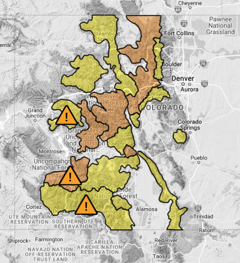
As far as weather warnings, the NWS out of Grand Junction issued a winter storm warning from Tuesday at noon through Thursday for the southwestern San Juan Mountains due to the chance for up to three feet of snow. The same warning applies to the Uncompahgre Plateau, which could see 10 to 20 inches of snow above 7,500 feet.
A winter storm warning means that heavy snow is occurring or will develop within 36 hours, and may be accompanied by winds stronger than 15 mph, according to the NWS.
Other winter storm warnings go into effect at 6 p.m. Tuesday through Thursday for the northwest San Juan Mountains (8-20 inches of snow forecasted), the Battlement and Grand Mesas (10-24 inches of snow forecasted), and the Uinta Mountains — which extend into Colorado from Utah — above 7,500 feet (8-10 inches of snow forecasted), the NWS said.
At 11 p.m. Tuesday, a winter storm warning will begin for the Flat Tops and the West Elk and Sawatch Mountains for 8-18 inches of snow. This warning also lasts through Thursday.
In addition to these warnings, a winter storm watch — meaning winter storm conditions are possible but the exact timing is not exact yet — was issued for the Elkhead and Park Range mountains through 5 p.m. Thursday as snowfall totals continue to shift in the forecast, NWS reported.
"One area that seems to not be very favored is the Elks and Central Mountain valley zone, including Vail and Vail Pass with storm total snowfall from Tuesday through Thursday only in the 3- to 6-inch range as they tend to be shadowed for the most part," the NWS said.

The NWS out of Boulder said Rabbit Ears Pass near Steamboat Springs will also see an increase in precipitation probability on Wednesday, and will see strong winds during the evening hours, which may lead to hazardous travel. A winter storm watch is in effect for heavy snow — 6 to 14 inches — and blowing snow from 11 a.m. Wednesday through 5 p.m. Thursday.
Along the foothills and Front Range, the system will arrive amid temperatures between 45 and 60 degrees, meaning any precipitation will come as rain.
This storm will turn into a rain-snow mix that will likely hit the eastern plains Wednesday night into Thursday morning. Little to no accumulation is expected there, the NWS said.
While the Utah Avalanche Center has warned about avalanches for the Abajo Mountains in southeast Utah, near the state border, no avalanche warnings are currently in effect for Colorado as of 11:30 a.m. Tuesday. An avalanche watch began at 11 p.m. Tuesday and will last through 5 p.m. Thursday.
The Colorado Avalanche Information Center (CAIC) warned of high avalanche danger on Wednesday afternoon through Thursday for the Grand and Battlement Mesas, San Juan Mountains (particularly the La Plata Mountains east to Wolf Creek Pass and north to Lizard Head Pass, Silverton, Telluride and the Cimarrons).
Visit the Colorado Avalanche Information Center's website for the latest information on avalanche danger in the state.
The NWS in Boulder said large and dangerous avalanches will be very easy to trigger in many places, and the slides will run naturally.
Snowfall will continue over the region Wednesday night, but will begin to lessen into Thursday morning. At that point, the chances of heavy snowfall increases in the central and northern mountains of Colorado. The area will see a break Thursday into Friday, but by Friday afternoon, another round of precipitation will move in.
This "looks to amount to much less snowfall accumulation than our previous AR (Atmospheric River) surges, with roughly 5 to 10 inches of snowfall for the southern mountains and southwest facing slopes of the central mountains," the NWS reported.
Unlike Tuesday and Wednesday's storm, the one on Friday will have a much colder air mass, which may result in better snow accumulations in the southern foothills and valleys late in the week, the NWS said. The system will continue east by Sunday morning.
On Sunday afternoon, the state will dry out and temperatures will return to either normal or slightly below normal.
MORE: Hourly forecast | Latest forecast | Radars | Traffic | Weather Page | 24/7 Weather Stream
Stream live, current temperatures plus radars across Colorado anytime for free on the free Denver7+ app on your TV or watch from your computer or mobile phone anytime.