


DENVER — If Colorado’s lackluster winter left you feeling a bit cheated, it appears Mother Nature is making some amends by bringing what forecasters are calling a “significant snowstorm” to the area that’s expected to impact the Wednesday morning commute and could lead to power outages in certain areas due to downed tree limbs.
Monday will remain a fairly mild day through the early afternoon hours before a shift in the weather begins to take shape. Scattered showers and a few thunderstorms will start to pop up after midday — first in the mountains and later in the plains — before a cold front from the north slides into the area.
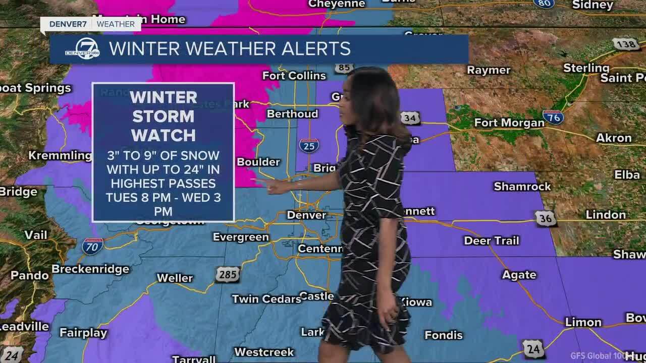
Denver7 meteorologist Danielle Grant has the full forecast in the video player below:
Forecasters said mountain snow will begin by late Monday while rain falls in the plains through Tuesday afternoon before it, too, transitions over to all snow by mid-to-late Tuesday evening, according to weather service officials.
The Boulder/Larimer County mountains (that is, areas north of I-70) are expected to receive the brunt of this storm, where localized snowfall amounts of around 2 feet of fresh powder are possible, they wrote in their forecast discussion earlier in the day. Around 1-2 inches of snow per hour are possible when the main event begins, a weather service official in Boulder said later Monday.
That much snow has prompted weather service officials to issue a winter storm warning that will be in effect midnight Tuesday through 3 p.m. Wednesday for areas along the northern Front Range foothills, including Red Feather Lakes, Estes Park, Nederland and the I-70 mountain corridor above 9,000 feet, as well as the southern foothills.
Areas south of the I-70 mountain corridor “should generally see 4-10 inches” of snow, aside from the high mountain passes (like Loveland Pass) and areas above 10,500 feet, forecasters said.

Check the latest Colorado winter weather alerts
That heavy, wet snow could be damaging, and travel conditions could become exceptionally difficult at times — especially on colder surfaces and west of I-25 — particularly for the Tuesday evening and Wednesday morning commutes, weather service officials wrote in a bulletin announcing a winter storm watch in effect from Tuesday evening through Wednesday afternoon for areas including Fort Collins, Boulder, Denver and its western suburbs, as well as Castle Rock.
A winter weather advisory will also go into effect Tuesday for the high mountain valleys and the Park Range starting at around noon Tuesday through 3 p.m. Wednesday, where between 2-14 inches of snow are expected, with those higher amounts forecast for the Park Range, weather service officials said.
State transportation officials are already urging drivers to prepare for the storm by making sure they have a snow kit inside their vehicles (think extra water, blankets, batteries, snacks and clothing). If drivers can stay home and avoid driving altogether, they should do so, they said.
"While daytime temperatures on Tuesday will initially keep most pavement wet in the Denver metro area, heavy banded snowfall is expected to create difficult travel conditions in the high foothills and mountain corridors, including I-70 Mountain Corridor, Larimer and Boulder counties, with slushy accumulations expanding south across the Palmer Divide by Tuesday night," a spokesperson for the Colorado Department of Transportation said late Monday afternoon.
There will be about 100 plows throughout the storm that'll focus on clearing interstates and major roadways first before the secondary roads. CDOT officials said the anticipated challenge with this storm "will be heavy wet snow possibly snapping tree limbs" that could fall onto roadways or power lines, creating potential power outages across major intersections. In the event of power outages, CDOT officials said drivers should treat intersections as four-way stops.
Though the models still show some uncertainty around impacts for the Denver metro, “there is still a 20-30% chance of snowfall amounts” of 8 inches or more for the Denver metro by Wednesday afternoon, forecasters said. Weather service officials said later Monday that depending on how far south that cold front from the north descends, the Denver area could see snow beginning to stick to roads, making the commute potentially more treacherous.
“If the higher-end solutions verify, this would lead to more significant tree/powerline impacts, as this is expected to be a wet and snow event for the plains,” they said, adding that “this late in the season, even lighter accumulations on roads tend to be much more problematic.”
Snow impacts are unlikely in the far east plains, forecasters said, as the majority of precipitation from this storm should fall as rain, though some slushy accumulation is possible, but not significant enough to create any widespread impacts.
How much snow can you expect in your area?
While there is still some uncertainty about how quick that colder air from the north will descend south to bring possibly more snow to the Denver metro, forecasters have released some "expected" and "high-end" snow totals for areas affected by the storm. You can view the full list here.
Arvada: 4" | 8"
Aurora: 5" | 7"
Berthoud Pass: 20" | 34"
Berthoud: 4" | 9"
Black Hawk: 13" | 19"
Boulder: 7" | 11"
Breckenridge: 9" | 14"
Brighton: 3" | 7"
Broomfield: 5" | 8"
Cameron Pass: 25" | 36"
Castle Rock: 7" | 9"
Centennial: 6" | 8"
Commerce City: 3" | 6"
Conifer: 13" | 18"
Cooper Mountain: 11" | 19"
Denver: 3" | 6"
DIA: 4" | 7"
Eldora: 20" | 27"
Elizabeth: 8" | 12"
Estes Park: 17" | 21"
Evergreen: 11" | 15"
Floyd Hill: 12" | 18"
Fort Collins: 4" | 9"
Georgetown: 14" | 21"
Golden: 8" | 11"
Greeley: 2" | 6"
Highlands Ranch: 5" | 8"
Idaho Springs: 11" | 18"
Kenosha Pass: 10" | 14"
Lafayette: 5" | 8"
Lakewood: 5" | 8"
Littleton: 4" | 6"
Longmont: 4" | 8"
Loveland Pass: 17" | 29"
Loveland: 3" | 9"
Nederland: 18" | 22"
Northglenn: 4" | 8"
Parker: 6" | 10"
Rabbit Ears: 8" | 20"
Red Feather Lakes: 23" | 29"
Vail Pass: 11" | 18"
Vail: 6" | 14"
Willow Creek Pass: 10" | 22"
Winter Park: 14" | 25"
By the second half of the week, things should turn around pretty quickly.
The colder air that will arrive with this spring snowstorm will move out , though there's still a chance the Denver metro and the rest of the Urban Corridor could wake up to below-freezing temperatures Thursday. Temperatures will rebound to more typical, even slightly warmer-than-normal levels, once the sun rises, however.
Highs will reach the low 40s both Tuesday and Wednesday before returning to the mid-60s and low-70s by the end of the week.
DENVER WEATHER LINKS: Hourly forecast | Radars | Traffic | Weather Page | 24/7 Weather Stream
Click here to watch the Denver7 live weather stream.