



As of Aug. 1, this story will no longer be updated every day. It will be updated with major developments.
OURAY COUNTY, Colo. — Crews are holding containment lines on Gold Mountain Fire in Ouray County, but burned areas along the U.S. Highway 550 corridor have remained susceptible to flash flooding, debris flows, and falling rocks, the incident management team said.
Extreme flooding due to heavy rain on the burn scar prompted an evacuation order in Ouray County on July 29, and closed the Imogene and Engineer passes. Both passes had reopened by Aug. 1.
The Ouray County Sheriff's Office also ordered evacuations for the area of Citadel Drive to Old School Road east of US 550 in the area of Ponderosa Village and Cutler Creek Drive between Ridgway and Ouray.
This fire, which started on June 27, has grown to 39,507 acres and is 67% contained, as of Aug. 1. It is burning in Ouray County, north of the small City of Ouray.
No structures have been reported lost. The cause is under investigation. Click here for the most up-to-date interactive map showing evacuations for this fire.
To sign up for emergency alerts, visit the Gunnison County website for its emergency management department, Hinsdale County's emergency alert signup page, and Ouray County's alert center website.
Friday, July 31
8 a.m. | Operational update | Fire officials working the Gold Mountain Fire said the following in an operational update Friday morning:
Thursday’s warmer and drier weather gave crews the opportunity to check the strength of containment lines on the north side of the fire, and there was an increase in containment along the perimeter in Division F.
Across the fire area, crews are retrieving water handling equipment, used for structure protection, to prepare it for deployment on other wildland fire incidents. Significant suppression repair work is also underway, which includes chipping, hauling, and scattering wood debris, clearing roadside culverts, and addressing erosion concerns.
Burned areas near the US 550 corridor remain vulnerable to flash flooding, debris flows, and falling rocks, according to fire officials. Residents in the area are asked to remain alert and use caution when traveling in and around this area, especially during and after storms.
Forest Service roads 864 and 858 remain closed south of Cimarron due to heavy equipment operations and debris removal. Residents and visitors should avoid this area to ensure personal safety and that of firefighting personnel.
Warm and dry conditions returned yesterday and are expected to persist through the weekend. As interior pockets of heat continue to dry out, visible smoke may increase. These interior hotspots pose no threat to containment lines, fire officials said.
Thursday, July 30
9 p.m. | Containment rises | Containment on the 39,506-acre fire has risen to 64%, according to an evening update from the incident management team.
7:58 a.m. | Acreage and containment latest | The Gold Mountain Fire estimate remains at 39,506 acres, but the containment has jumped to 62%, according to the incident management team.
Wednesday’s heavy rain brought flash flooding across the southwest region of Colorado, and burned areas near the US 550 corridor remain vulnerable to flash flooding, debris flows, and falling rocks, according to fire officials. Residents are urged to remain alert and use caution when traveling in and around this area, especially during and after storms.
Forest Service roads 864 and 858 remain closed south of Cimarron due to heavy equipment operations, debris removal, and ongoing firefighting. Residents are asked to avoid this area to ensure personal safety and that of firefighting personnel.
Fire officials said overall fire activity on the Gold Mountain Fire has slowed significantly, but firefighters are actively patrolling for remaining hot spots and stand ready to suppress any flare-ups. Priorities currently focus on suppression repair work and removing structure protection equipment.
Weather is expected to turn warmer and drier heading into the weekend, allowing fire managers to assess the strength of constructed containment lines.
Wednesday, July 29
8 p.m. | Flash flood evacuations | The Ouray County sheriff's office ordered evacuations for the area of Citadel Drive to Old School Road east of US 550 in the area of Ponderosa Village and Cutler Creek Dr between Ridgway and Ouray "due to active intense flooding." The evacuations were ordered at 6:20 p.m.
"Extreme flooding is occurring in this area due to heavy rain on the Gold Mtn burn scar," the post said. Ridgway Secondary School is open as an evacuation center.
The flooding also prompted the closure of US Highway 550's Red Mountain Pass. Colorado Department of Transportation officials said the closure between Silverton and Ouray would remain in place overnight.
"Several ridgelines and drainages along the entire pass corridor are experiencing severe rains resulting in flooding, mudslides and rockfall between Silverton and Ouray," CDOT officials said in a travel alert.
8:05 a.m. | Acreage and containment latest| The Gold Mountain Fire is now estimated at 39,507 acres and containment has grown to 59%, according to the incident management team.
While fire activity remains low, burned areas near the US 550 corridor are vulnerable to flash flooding, debris flows and falling rocks, the incident management team said Wednesday morning. There may be some visible plumes of smoke Wednesday, but it doesn't pose a threat to containment.
The western side of the Gold Mountain Fire is largely contained, and crews are largely working on Division U, visible at the top of the map below.
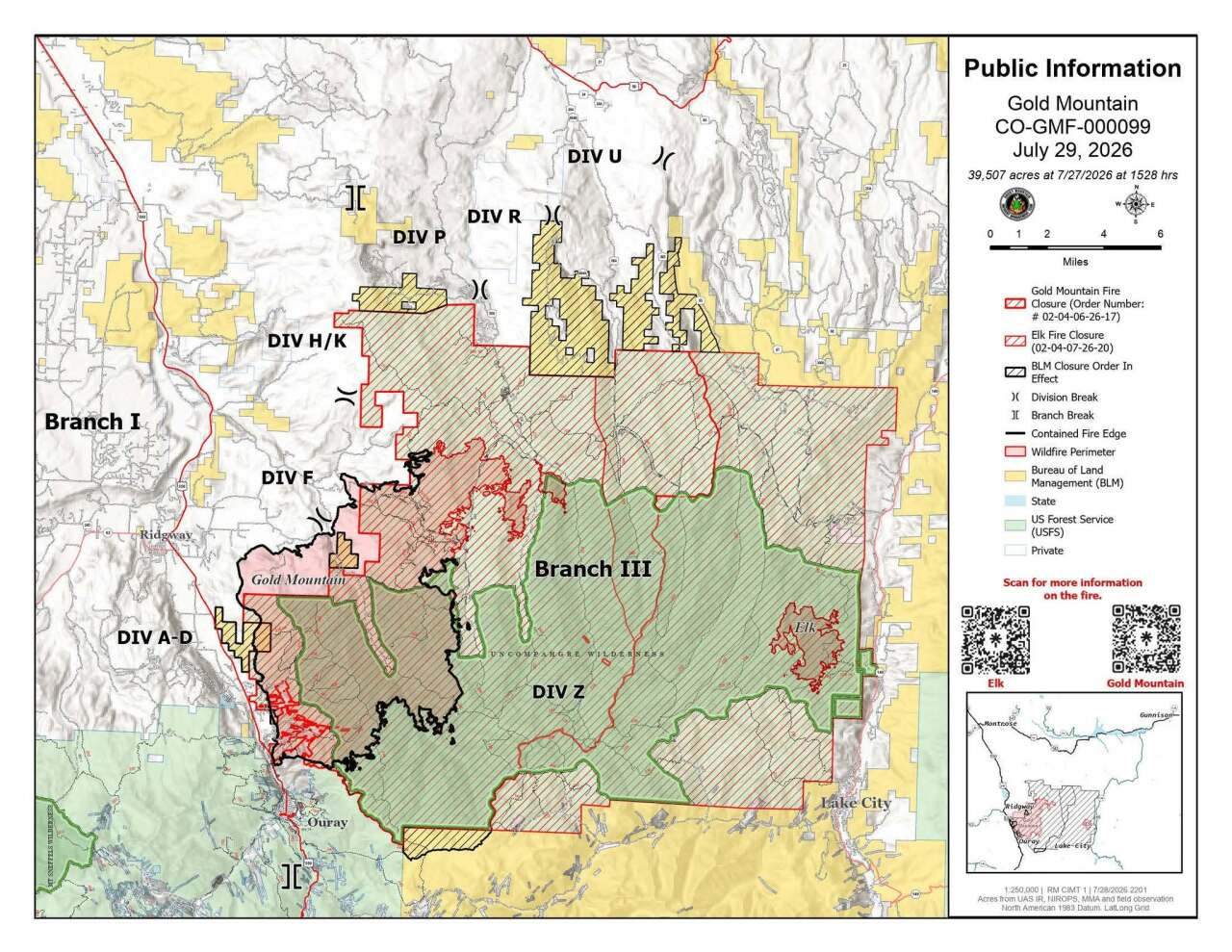
Tuesday, July 28
9 a.m. | Operational update | Fire officials working the Gold Mountain Fire provided the following operational update:
The Gold Mountain Fire's size and containment has grown following updated mapping and modeling, which has provided a more accurate picture of the fire’s interior footprint. Fire officials said fire activity remains low throughout the Gold Mountain Fire.
As it stands Monday, the fire is now 39,506 acres and containment has reached 50%.
Crews battling the blaze continue making progress on suppression repair work, strengthening indirect contingency lines, and deploying heavy equipment on narrow roads and assessing opportunities for indirect fire suppression.
Scattered showers and thunderstorms are forecast through Wednesday with conditions peaking this afternoon and evening, according to fire officials. Flash flooding, heavy rains, lightning, and winds up to 40 mph are expected.
Fire officials said slow backing fire may be observed, but that does not currently pose a threat to established containment lines.
Monday, July 27
8 a.m. | Operations update | Scattered thunderstorms will bring more lightning, strong winds and heavy rain around the burn scar, which is vulnerable to flash flooding, debris flows and falling rocks.
"Monsoonal moisture with afternoon thunderstorms capable of heavy rain, lightning, small hail, and strong winds is expected today and throughout the week. Interior smoldering may continue to produce smoke during warmer, drier periods," according to Inciweb.
Containment increased to 37%.
Friday, July 24
8 p.m. | Containment and acreage holds | The Gold Mountain Fire remains at 38,052 acres and 27% contained, according to an evening update from the incident management team.
Fire behavior remained moderate Friday, and parts of the fire area received up to three-quarters of an inch of rain, according to the incident management team.
"Although beneficial, crews were forced to disengage from portions of the fire earlier than planned due to nearby thunderstorms and changing weather conditions," the update said.
Thursday, July 23
8 p.m. | Containment rises | Containment rose to 27% Thursday evening.
"Fire activity remained well within expectations, and no significant growth occurred," an evening update from the incident management team said.
9 a.m. | Operational update | In an operational update Thursday morning, fire officials working the Gold Mountain Fire said the following:
On the southern side of the fire, firefighters continue to progress with suppression repair. Adam Ziegler, the operations chief with Rocky Mountain Complex Incident Management Team 2, said all divisions of the fire received "significant moisture" which was good for the fire, but does delay firefighting on the ground.
Firefighters are also continuing suppression repair work across several divisions on the western and northern side of the fire. On the eastern side, the fire is still backing its way down the hill but firefighters will resume work to build containment lines.
Ziegler said the evacuation status of Zone 32 in Gunnison County was moved down to a voluntary evacuation status, "however, the public lands are still under a closure order."
Wednesday, July 22
8:40 p.m. | Operations update | Cooler, wetter conditions kept fire activity low on Wednesday. Containment and acreage held throughout the day. While some rain fell over the fire area, it was fortunately not enough to create flash flooding, according to the evening update.
8:05 a.m. | Latest on acreage and update on containment | The Gold Mountain Fire remains at 38,044 acres and 24% containment Wednesday morning, according to the incident management team.
Tuesday, July 21
10:30 a.m. | Operations update | Operations Section Chief Adam Ziegler explained that along the south end of the fire, "things continue to look really good."
Crews are also focusing on suppression repair along the southern end as well, including erosion control measures with future rainstorms.
"The big activity" on the east side continues, he said. Firefighters are monitoring the fire on this side as it continues to back down toward the firelines, which are already in place.
"Everything is going very well. The fire is doing exactly doing exactly what we hoped it would do," Ziegler said.
Along the southeast side, firefighters are getting more containment. While they can't access this area due to the steep terrain, aircraft have flown over the area often and confirmed the fire has burned up to solid rock and is no longer progressing.

8:27 a.m. | Latest on acreage and update on containment | The Gold Mountain Fire containment has jumped to 24% as the size was only estimated to have grown to 38,044 acres, according to the incident management team.
Monday, July 20
8:48 a.m. | Latest on acreage and update on containment | The Gold Mountain Fire is estimated at 38,009 acres and remains at 13% contained, according to the incident management team.
Saturday, July 18
Noon | Flood threat | The burn area is under a moderate flood threat as thunderstorms that could bring heavy rain are forecasted for the afternoon, according to the Colorado Flood Threat Bulletin.
"Flood threats include excessive runoff, isolated debris flows over steep terrain, and flash flooding in dry streams and creeks," the posting said.
Officials advised those in the burn area to get flood insurance added to their insurance policies.

8:30 a.m. | Safety message + operations update | The incident management team issued a safety message about flash flooding amid increasing thunderstorm activity.
"Burned soil can be as water repellent as pavement, causing rainfall to run off extremely quickly and increase flood risk," the update said. "Debris and ash left from the fire can form hazardous mudflows."
Containment is holding at 13% and the fire is currently 37,809, according to the update. Fire activity remains greatest in high elevations.
"Although aspects of the Gold Mountain Fire will take weeks to resolve, crews are taking advantage of this period of favorable weather to strengthen defensible lines and prepare for potential increase in fire activity," the morning update said.
Friday, July 17
9 p.m. | Operations update | The incident management team said in an evening update that Friday operations were "relatively quiet." A storm that tracked over the fire brought nearly an inch of rain to the northern portion of the fire, and there was limited fire activity throughout the day, the update said.
The fire remains at 37,734 acres and is 13% contained, according to the update.
2:45 p.m. | Mop up continues |Areas of the Gold Mountain Fire are continuing to become "more secure," according to a post from The incident management team, and crews are completing mop-up operations.
The post said residents may still see smoke rising from within the fire perimeter, and that seeing smoke "does not necessarily indicate new fire growth."
As of the morning update from the incident management team, the fire is at 37,334 acres and is holding at 13% containment.
Thursday, July 16
8:31 p.m. | Containment increases | Fire behavior "remained minimal" Thursday and containment increased to 13%, according to an evening update from the incident management team.
10:16 a.m. | Operations update | The east side of the fire remains in mop-up mode. Crews continue to work along the northern edge of the fire after it came down into better terrain for firefighter access. A group is continuing to work on structure protection to the north.
7:09 a.m. | Operational update | An additional mapping flight was conducted overnight, bringing the current fire size to 37,734 acres, according to the incident management team. It is 11% contained.

Wednesday, July 15
8:20 p.m. | 'Steady progress' | In a Wednesday evening update, the incident management team said crews had made "steady progress" on the fire, and cooler temps and overnight humidity were expected to help build on that progress.
The fire remains at 37,259 acres and 11% containment.
9:52 a.m. | Operations update | Operations Section Chief Adam Ziegler explained that the southwest section of the fire is in a mop-up stage. Crews are still in the community and looking for any places where smoke is still popping up. Farther north along the west section, crews are doing more of the same, Ziegler said.
On the northwest section of the fire, firefighters are mopping up the fire's edge and working to secure it.
The crews that are ahead of the fire on the north side are continuing to strengthen firelines.
Some spot fires are burning northeast of the fire in terrain that firefighters can not access. The south side of the fire has remained unstaffed, but aircraft are patrolling it.
A structure protection group is working around homes north of the fire.
Multiple aircraft will fly the fire on Wednesday.
8 a.m. | Acreage and containment update | 37,259 acres have been burned in the Gold Mountain Fire, as of Wednesday morning, according to the incident management team. It remains at 12% contained.
Tuesday, July 14
6:00 a.m. | Acreage and containment update| The Gold Mountain Fire stands at 36,965 acres with 12% containment, according to the Rocky Mountain Complex Incident Management Team 2, which has taken command from the Rocky Mountain Complex Incident Management Team 3.

Monday, July 13
2:59 p.m. | Pre-evacuation orders for Elk Fire | The Elk Fire burning near the Gold Mountain Fire now has a pre-evacuation order for Zone Gun-220 in Gunnison County. Click here for the most up-to-date interactive map showing evacuations for this fire.
6:53 a.m. | Latest on acreage and containment | The Gold Mountain Fire has now burned through 36,259 acres, while. containment has jumped to 11%,
Sunday, July 12
9 p.m. | Aircraft crash | A pilot fighting the Gold Mountain Fire has crashed into a Gunnison County reservoir, according to the local sheriff's office.
At 5:17 p.m. on Sunday, the Gunnison Regional Communications Center received a report that an aircraft had gone down in the Silver Jack Reservoir in the southwest part of the county, the Gunnison County Sheriff's Office said.
We have our breaking news story here and below.

Wildfire
Firefighting pilot at Gold Mountain Fire dies after crashing into reservoir
7:48 a.m. | Operations update | The Gold Mountain Fire has remained active so far this weekend, according to the incident management team.
"Firefighters are continuing to secure the edge along Highway 550 and are ensuring that firelines along County Road 12 hold against reburn potential," they reported. "The potential for reburn is higher in the oak brush fuel type as the shrubs shed leaf litter that burned during the initial burn has dried out the canope which could reignite with the right heat and wind conditions."
A helitack crew worked along the southern edge of the fire.
Saturday, July 11
3 p.m. | Overall update | Fire containment dropped slightly to 6% and 34,848 acres have been burned, as of the Saturday morning update. Officials said drones have flown into the fire's Temporary Flight Restricted Area: "When this happens, all air operations are grounded putting firefighters and public lives at risk. Remember, IF YOU FLY, WE CANNOT," wrote officials on social media.
Friday, July 10
9 p.m. | Increase in fire activity | The northern side of the fire has been active Friday evening, which the incident management team said is a combination of a few things. They said it's due to:
- The fire becoming became established in Nate Creek and beginning to run up the side of the mountain to the east
- Spot fires becoming active in dense timber on the east side of the West Fork of the Cimarron
- The fire activity from both east and west converging to create a large smoke column
The time lapse video they shared in the post below was taken from the Ouray County Fairgrounds. It condense 45 minutes until about 2 minutes.
8:07 a.m. | Fire behavior | The most significant growth of the Gold Mountain Fire occurred in the Nate Creek area, where a large spot fire progressed northeast along the west side of Cimarron Ridge, according to the incident management team.

6:23 a.m. | Latest on acreage and update on containment | The Gold Mountain Fire was measured at 33,185 acres Friday morning and stands at 7% contained. On Thursday, it was estimated at 8% contained. The incident management team said the slight dip is due to strategic firing operations in the area of Owl Creek and Road 858 over the past two days.

Thursday, July 9
10: 15 p.m. | New fire | A new fire, dubbed the Elk Fire, is burning east of the Gold Mountain Fire. Aerial resources from the Gold Mountain Fire have also been assisting in the response, according to a post from the Gold Mountain Fire's incident management team. Read more here.

9:35 a.m. | Operations update | Operations Section Chief Jeramy Dietz said firefighters continue to gain good containment along US 550 and around Ouray and the Lake Lenore area. Firing operations on the northwest side of the fire has also been successful. Over the next four to five operational periods, he said crews will start to gain more secure lines.
6:43 a.m. | Update on acreage and containment | The Gold Mountain Fire has burned through 32,131 acres, but remains at only 8% contained, according to the Gold Mountain Fire Facebook page.
Warm, dry weather will continue to increase fire potential across the wildfire area through the end of the week, Rocky Mountain Area Complex Incident Management Team 3 said.
Wednesday, July 8
12:15 p.m. | Fire update | Fire managers are going to move forward with strategic firing operations along the fire's northwest edge. This means they will burn fuel ahead of the fire, and between its perimeter and current firelines. This will slow down the fire's progress, the incident management team said.
As a result of this, the size of the Gold Mountain Fire will increase, which may also impact the containment percentage.
8 a.m. | Operations update | Areas of the Gold Mountain Fire continued to burn in the interior of this fire Tuesday, but activity remained "relatively quiet" on Tuesday, according to the incident management team.
While storms did roll through, they did not bring the strong winds that were anticipated.
Infrared mapping shows very little heat along the Highway 550 corridor, where minimal fire growth is expected.
Fire activity is expected to remain low to moderate on Wednesday.
7:50 a.m. | Update on acreage and containment | The Gold Mountain Fire now totals at 31,420 acres, while it is 8% contained, according to the Gold Mountain Fire Facebook page.
Tuesday, July 7
8:22 p.m. | Limited re-entry | Beginning at 10 a.m. Wednesday, Ouray County Sheriff approved reentry for those in Zones 12 and 13. This includes the roads along the 550 Corridor including all roads off of CR 14, Portland, White House Vista Lane, Old School Road and Redstone Road. Credentials are required to enter the area.
5:50 p.m. | Incident meteorologist | Denver7 reached out to the National Weather Service to learn more about the incident meteorologists who have been called to several of Colorado's wildfires, including the Gold Mountain Fire. On Tuesday, we spoke with one of them about the unique role they play at these disasters.
Click here for an inside look at their daily responsibilities.
1:11 p.m. | Help from across the U.S. | People from 34 states are currently assisting at the Gold Mountain Fire.
8:23 a.m. | Operational update | The most active part of this fire remains in the northern and northwestern portions, according to an incident management team update. Strategic firing operations, where firefighters remove fuel ahead of a fire so it has nothing to burn, has strengthened containment lines.
Most of this fire is burning in the Uncompahgre Wilderness Area, where it has not burned in more than 50 years, the team said.
Monday, July 6
12:56 p.m. | Prep for re-entry | While it's not yet clear when evacuated residents can return home, Ouray County Emergency Management is preparing by starting a credential process on Tuesday. Here's more from the county:
- Date: Tuesday, July 7, 2026
- Time: 1-7 p.m.
- Location: Ridgway Elementary School, 1115 Clinton St.
- What to bring? For reentry credentialing, property owners and residents must bring valid documentation that shows the address of a property in the reentry area. County staff will have a list of all impacted properties to verify.

9:57 a.m. | Operations update | In an operations update video posted Monday morning, Operations Section Chief Jeramy Dietz said while crews have secured containment on the south end of the fire, firefighters are staying vigilant and will continue to have a presence there.
Dietz explained that divisions are in place farther north of the fire, as experts were not able to find any good place to put resources closer to the line. Firefighters in those northern divisions are building firelines, should the blaze reach them. If conditions change, the crews will adapt, Dietz said.
He said he expects to gain more containment on the southeastern edge of the fire in the next few days.

9:21 a.m. | Incident management team update from Sunday efforts| Firefighters were able to reinforce indirect containment lines between Baldy Peak and County Road 12 on Sunday afternoon, thanks to lighter winds and better conditions. These efforts will help protect Ridgway, Ouray, the US 550 corridor and communities north and northwest of the fire.
The 3% containment is on the southern edge of the fire, the Rocky Mountain Incident Management Team reported.
There is a 30% chance of thunderstorms that may bring erratic winds and lightning on Monday.
8:08 a.m. | New evacuations | Gunnison County has announced new mandatory and voluntary evacuation orders.
The mandatory evacuations are now in place for the area south of Storm King and east of Cimarron Ridge to County Road 864A in the Cimarron Valley to the U.S. Forest Service boundary. This includes the Bear Claw, Silver Jack, Eagle's Rest, and Little Bighorn subdivisions, according to the Gunnison County Emergency Management department.
Voluntary evacuations are in place for the area east of County Road 864A and west of Big Blue Creek, up to the BLM boundary; and south of the intersection of County Road 883 and County Road 864, also known as Little Cimarron; and north of the U.S. Forest Service Boundary. This includes Johnson Park Road and Little Cimarron Road within this boundary.
Sunday, July 5
3:27 p.m. | Update from firefighters | Steep and rugged terrain stopped firefighters from putting fireline directly at the fire's edge in the Baldy Peak area on Sunday afternoon. Instead, the crews constructed indirect containment lines from Baldy Peak to County Road 12, according to fire officials.
Firefighters tested out this line at 3 p.m. on Sunday, which "led to the decision to move forward," officials wrote on the Gold Mountain Fire Facebook page.

"This afternoon and evening, smoke from strategic firing operations will be very visible from the Baldy Peak area to the town of Ridgway and the Highway 550 corridor," fire officials said. "Once completed, the firelines will provide firefighters with a line of defense with the highest probability of success should the fire spread in that direction."