
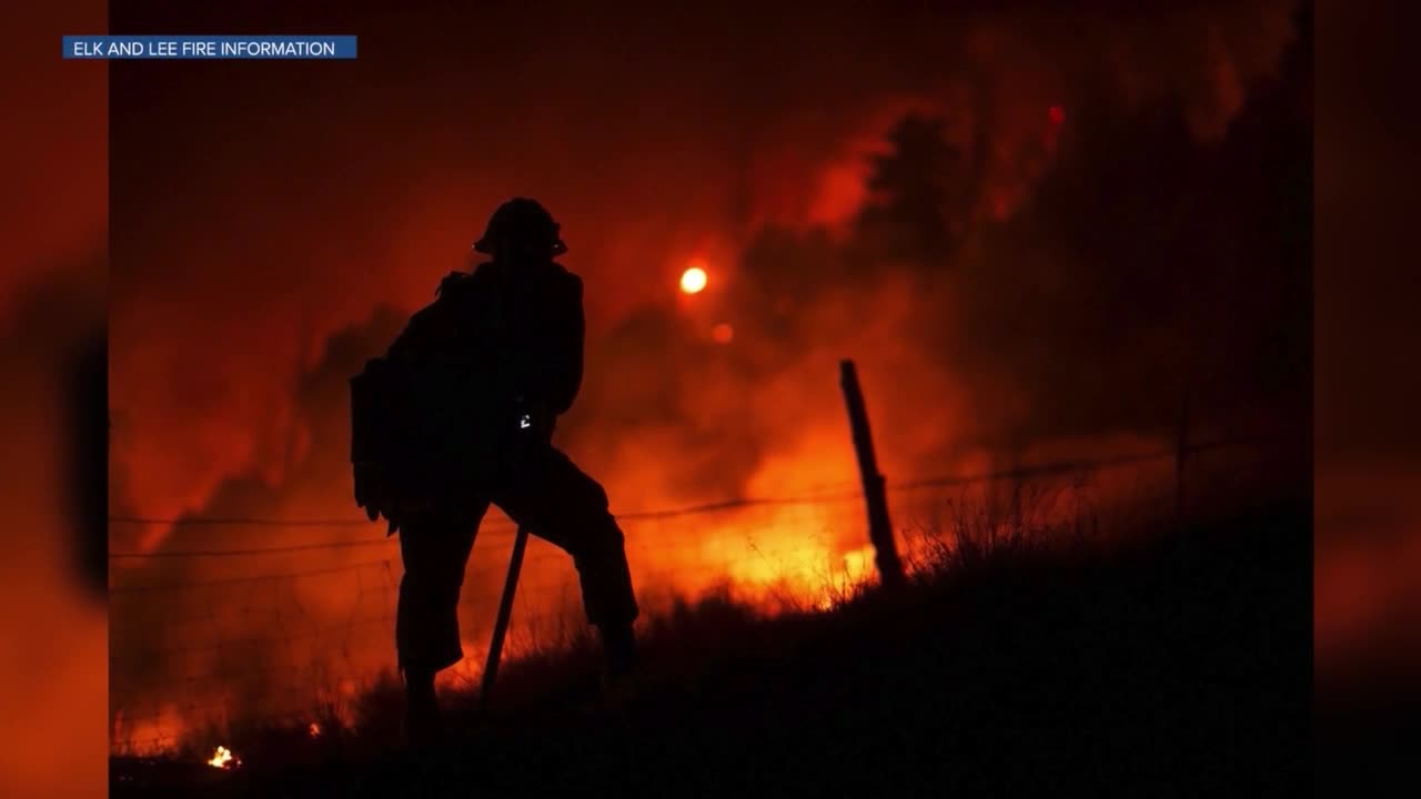


DENVER — As classes start in the Meeker School District on Monday, firefighters continue to fight to increase containment levels at the two blazes near the community, as well as others across Colorado's Western Slope.
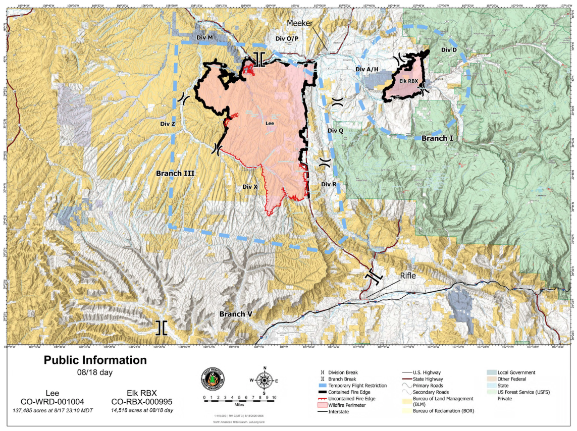
Denver7 shared some good news on the wildfire front on Sunday, when the 14,518-acre Elk Fire reached 100% containment. That fire was first reported on Aug. 2, about 11 miles southeast of Meeker after a lightning strike. Since then, and as of Monday morning, 47 miles of fireline was constructed around its perimeter, according to the incident management team at the scene.
On Monday, crews at the Elk Fire will continue to repair the dozer lines, hand lines and other areas that were impacted by the firefighting efforts, the incident management team said. This will also help prevent future erosion and sedimentation.
"Crews are covering contingency lines with soil and spreading vegetation to help restore areas affected by firefighting operations to near pre-fire condition," the incident management team said.
Meanwhile, the Lee Fire, on the southwest side of Meeker, has burned 137,755 acres and is 68% contained as of Tuesday evening. It was sparked by a lightning strike and has burned at least three homes and 12 outbuildings.

The Lee Fire has grown to become the fifth-largest wildfire in the state. It sits narrowly behind the 2002 Hayman Fire, which burned 137,760 acres north of Lake George.
On Saturday, firefighters worked to mop up hotspots on the south and west side of the fire to strengthen the containment lines. Crews continue to patrol Highway 13 and the north and northwest edges of the fire. To start this week, they will continue suppression repair efforts.
An unmanned aerial system flew the Lee Fire on Sunday and confirmed no flames had escaped the established perimeter.
"We've been wind-tested, weather-tested, and everything is holding right now, so we'll continue to have good ground presence in there and try to establish some containment here in the next couple operational periods," Jeremy Dietz, operations section chief with Rocky Mountain Complex Incident Management Team 3, said during a Monday morning update on Facebook.
The plan for Monday for the Lee Fire revolves around monitoring those containment lines, identifying hotspots and mopping up the south and west sides of the fire.

"Rocky Mountain Area Complex Incident Management Team 3 is coordinating closely with the Bureau of Land Management and other agencies to plan future repairs that meet established standards," the incident management team said.
Many evacuations for both the Lee Fire and Elk Fire were downgraded or lifted on Monday. For exact details on evacuations, the Rio Blanco Sheriff's Office asks residents to use this map to see exact evacuation statuses. County Road 5 remains closed.
Check on the latest updates for these fires on the Elk and Lee Fire Information Facebook page, the Rio Blanco County Sheriff's Office Facebook page, and the InciWeb page for the Lee Fire and InciWeb page for the Elk Fire.
Weather on both of these fires will stay hot, dry and sunny on Monday, with light winds about 5 to 10 mph.
On Aug. 14, Colorado Gov. Jared Polis signed an executive order declaring a disaster emergency due to the critical fire weather conditions.
Denver7 is tracking several other wildfires on Colorado's Western Slope. Below is our roundup on where each one is burning, containment amounts and where residents can learn more details.

Size: 2,067 acres
Containment: 22%
First reported: Aug. 11 at 3:25 pm.
Cause: Unknown
Location: Routt National Forest in Rio Blanco County
Evacuations 🏠: See a map of the evacuation zones here
As of Monday morning, the Crosho Fire was still threatening 240 structures, according to the Wyoming Type 3 Incident Management Team. However, none had been destroyed as of 9 a.m.
Over the weekend, some evacuation orders were lifted and residents were allowed to return home. Fire Zone 2 remains under evacuation, as of noon Monday.

"Moderate" fire behavior continues on the north side of the Crosho Fire, near South Spronks Creek, the incident management team said. Aerial operations will continue on Monday, along with work on the ground, to secure sections of fireline from Crosho Lake east along County Road 15. The steep terrain around the fire continues to pose a challenge, the management team said.
"Protecting the safety of both firefighters and the public remains the highest priority. Hand crews and dozers, supported by aerial resources, are carrying out full suppression efforts," the team said.
Cool temperatures, calm winds and light precipitation over the weekend helped firefighters gain some containment. This week will stay warmer and drier, which may increase fire activity.
An emergency closure order is in place for the Medicine Bow-Routt National Forests around the fire. The Routt County Emergency Incident Map is updated with road closures.
Updates posted to:
InciWeb
Crosho Fire Information
Rio Blanco County Sheriff's Office

Size: 9,006 acres
Containment: 10%
First reported: July 28
Cause: ⚡️
Location: 5 miles west of Rico in the San Juan National Forest
Evacuations 🏠: No current evacuations
A warming and drying trend in the weather is expected over the Stoner Mesa Fire on Monday, so there is an increased risk in fire activity.
"Firefighters continue to make good progress on containment lines in areas where the fire has been the most active while continuing to scout for opportunities for indirect containment lines in inaccessible parts of the fire," the incident management team said.
Operations Section Chief Matt Weakland with Rocky Mountain Incident Management Team 1 provided an update on Facebook on Monday. He warned that the community of Stoner, just southwest of the fire's perimeter, will see an increased number of fire personnel over the next few days as firefighters ensure that side of the fire is "very well taken care of." Recently, that has been the most active part of the fire. It will continue to be active over the next few days, he said.
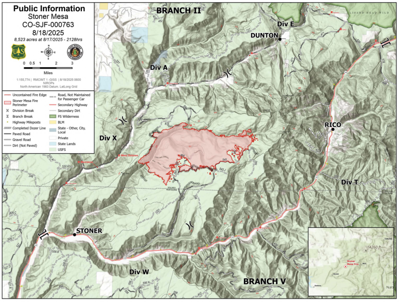
"We're putting a lot of focus on building our lines through here and taking care of this Stoner Creek drainage," he said.
The northeast edge of the fire is in a very challenging area, he explained. The team is still planning how it will attack that area. The opposite side, on the northwest edge, is moving into the mopup stage, which will take several days before authorities can officially call it contained there.
Along the southern edge, more mopup work will continue this week, but "things are looking really good on this portion of the fire," Weakland said.
To sign up for Dolores County emergency alerts, click here. To sign up for Montezuma County emergency alerts, click here.
A community meeting is scheduled for Monday at 6 p.m. at the West Fork Fire Department, located at 12002 Road 38 in Dolores. This meeting will be livestreamed on Facebook and a recording will be posted on YouTube.
Updates posted to:
Stoner Mesa Fire Information
USDA Forest Service Facebook page
InciWeb

Size: 31,698 acres
Contained: 79%
First reported: July 10
Cause: ⚡️
Location: 8 miles northeast of Gateway in Mesa County
Evacuations 🏠: All evacuation orders have been lifted
On Monday, crews will continue to patrol the western perimeter of this fire to extinguish hotspots, while others address heat pockets along the southern edge. They continue to make steady progress, according to Northern Rockies Incident Management Team 3.
Residents who live nearby may see some smoke on Monday as the fire reaches isolated pockets of unburned foliage within the perimeter. This smoke will help firefighters quickly identify and extinguish those spots.

"Spread potential is minimal, as winds are expected to remain light," the management team reported. "However, as warm, dry conditions persist through the week, residents could see increased smoke from the fire."
Winds are expected to stay light, with some gusts up to 15 mph.
Updates posted to:
InciWeb
Turner Gulch Fire Info.
Upper Colorado River Interagency Fire Management Unit Facebook
Mesa County Sheriff's Office page on Facebook

Blue Ridge Fire
Size: 25 acres
Containment: 100%
First reported: Aug. 15
Cause: Under investigation
Location: La Plata County
Notes: All evacuation and pre-evacuation orders lifted on Aug. 18.
Oak Fire
Size: 75 acres
Contained: 78% (as of last update on Aug. 13)
First reported: Aug. 10
Cause: Structure fire
Location: Archuleta County west of Pagosa Springs
Notes: The Archuleta County Sheriff's Office said two suspects have been arrested in connection with an illegal burn that started this fire. The suspects have been identified as Sergio Alaniz Jr., 41, and Ross Heirigs, 60. They were arrested on charges of fourth-degree arson.
Peninsula Fire
Size: 17 acres
Containment: 80% (as of last update on Aug. 10)
First reported: Aug. 8
Cause: ⚡️
Location: South of Highway 145, between Norwood and Placerville
Yellowjacket Fire
Size: 29 acres
Contained: 40% (as of last update on Aug. 16)
First reported: Aug. 15
Cause: Unknown
Location: Northeast of Meeker
Deer Creek Fire
Size: 17,724 Acres
Containment: 100%
First reported: July 10
Cause: Under investigation (as of last update on Aug. 12)
Location: Eastern Utah and Montrose County (Colorado)
South Rim Fire
Size: 4,232 Acres
Containment: N/A (National Park Service says 100% containment likely will not occur until snowfall, but "fire behavior is limited to smoldering and creeping, and poses very little risk of spread outside the current fire footprint.")
First reported: July 10
Cause: ⚡️
Location: Black Canyon of the Gunnison National Park
Leroux Fire
Size: 195 Acres
Containment: 100%
First reported: Aug. 3
Cause: ⚡️
Location: Delta County
Wright Draw Fire
Size: 466 acres
Containment: 100%
First reported: July 10
Cause: ⚡️
Location: Mesa County
Windy Gap Fire
Size: 30 acres
Containment: 100%
First reported: Aug. 6
Cause: Unknown
Location: Grand County


Denver7 is committed to making a difference in our community by standing up for what's right, listening, lending a helping hand and following through on promises. See that work in action, in the videos above.