


Predicting and preparing for avalanches that threaten Colorado's US 550 — arguably the most dangerous stretch of highway in the lower 48 states for slides — comes with unique challenges that avalanche forecasters have faced for decades.
In dry months, US 550, particularly the stretch called Million Dollar Highway, is a curvy, sometimes anxiety-inducing ride that makes up for its narrow lanes and sporadic lack of guardrails with jaw-dropping views of the steep cliffs along the Uncompahgre Gorge. But on wintry days, the addition of snow, ice, poor visibility, and an ever-present threat of avalanches can transform the road into a frozen hellscape.

For 30 years, the Colorado Department of Transportation (CDOT) has worked with the Colorado Avalanche Information Center (CAIC), now led by director Ethan Greene, to monitor risks and conditions, and close US 550 when storms rage too strong.
"It cuts right through the heart of the San Juan Mountains," Greene said. "These are really big peaks, very steep terrain. They are loaded with avalanche paths."
With 124 chutes along US 550 — about a fifth of the total 540 paths monitored statewide — CAIC avalanche forecasters stay busy every winter keeping travelers safe as they drive the road, which cuts across the middle of the precipitous slopes, meaning avalanches charge downhill and across the highway at speeds reaching 150 mph and beyond until they’re slowed by level terrain.
READ MORE: The Million Dollar Highway’s steep history as one of Colorado’s most scenic passes
A good chunk of Colorado's US 550 is called the Million Dollar Highway, which runs about 20 miles between Ouray and Silverton, the latter of which relies on US 550 as a lifeline for mail, goods and services. In some places along US 550, the two lanes narrow down to just 23 feet wide. It leads travelers up and down Red Mountain Pass, Molas Pass and Coal Bank Pass, through a vast and mostly undeveloped part of Colorado beloved by many outdoor enthusiasts. Signs along the way warn drivers to not stop or stand under avalanche chutes.
"It is a beautiful place," Greene said. "It is a really a stunning drive. It has lots of history. And a lot of that history is tied to avalanche occurrences in that area."
US 550 is one of the worst roadways in the lower 48 states for avalanche danger, as detailed on FEMA's Avalanche Hazard Index.
So, it takes somebody special to tackle the job of forecasting avalanches here. The location is remote, stakes are high, and responsibilities are intense. But for the right person, it's a dream.
And CAIC just hired a new person for the position.
But the job of forecasting avalanches along US 550 was born out of tragedy 30 years ago. In its wake, and for the first time, two experts with CAIC were selected to study and manage the slides that plagued the highway. The men went face-to-face with the so-called White Death, mastered the snowy rhythms and patterns along each curve and ultimately led the way for modern forecasting.
Deadly decades for avalanches along Million Dollar Highway
In the pre-sunrise hours of March 5, 1992, a storm seethed over the San Juan Mountains.
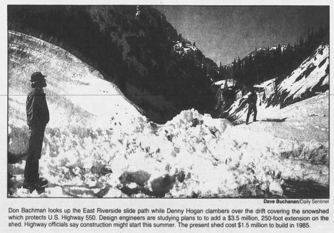
On the top of Red Mountain Pass along US 550, snow piled up like a tightening hug on the high-angled slope. About every hour, the icy grip that kept the mile-long East Riverside Slide — historically the area of most concern along the highway — clinging to the side of Abrams Mountain would release, sending tons of snow diving downhill.
As reported by The Daily Sentinel two days later, a six-person CDOT crew hunkered under the road's one and only snowshed, which provided an angled platform for tsunamis of snow to crash over before falling to the bottom of the gorge, all while protecting any people or vehicles under its roof.

The group carefully timed each 60 minutes. The shed, built out of $2.7 million in 1985, was only 185 feet long and snow on either side of it was piling up.
Around 3 a.m., David Jaramillo, then-36 years old, ran outside on the north end of the snowshed to try to fix one of their CDOT vehicles before the monster above them was unleashed again. The crew's supervisor, Eddie Imel, 38, watched before rushing out to help him, the newspaper reported.
He knew time was running out.


Sixty-five minutes after the previous slide, the familiar but feared rumble came from above. It happened fast: A wall of snow crashed into both Jaramillo and Imel, sweeping them out of sight of their coworkers, who watched horrified from under the snowshed.
The avalanche raced 200 mph down the slope when it hit the men, the newspaper reported. Once it slowed to a dribble, the four coworkers ran to where they had last seen the two men and detected one of their avalanche beacons. They all started to dig.
But as the storm raged on, so did their fears of East Riverside plummeting down again, and they retreated to the snowshed, trapped until rescue crews arrived about eight hours later.

The group later learned that both buried men were alive and could hear them in the immediate aftermath. Jaramillo said he couldn't respond, though — snow was packed in his mouth.
The newspaper reported that the men miraculously managed to find each other within the icy debris and dug a cave. For the next several hours, Jaramillo tried to keep Imel from falling to hypothermia. Once that became futile, Jaramillo started to self-rescue.
Eighteen hours after the slide, he dug through 20 feet of snow "hard as concrete" and emerged, the newspaper reported. Imel, however, died of hypothermia.
Hundreds attended his funeral.


This was far from the first fatality along US 550. The East Riverside Slide had stolen the lives of five other people since 1963, all of them before the protective snowshed was built.
That included two other snow-plow operators: 36-year-old Robert F. Miller on March 2, 1970 (which prompted the then-Ouray mayor to write a song called "Riverside Slide") and 28-year-old Terry L. Kishbaugh on Feb. 10, 1978. Three crosses along the highway still mark where Rev. Marvin Hudson and his two daughters, 11 and 17 years old, died on March 3, 1963, after the same slide let loose, according to The Daily Sentinel newspaper printed on March 12, 2000.
A marker for the family along the highway reads that they were "swept to their deaths 1,000 feet north of this marker in the East Riverside Slide Sunday March 3, 1963 while answering the call to Christian duty of his pastorate in Silverton, Colorado."
Next to it is another marker dedicated to "those who have given the supreme sacrifice in the maintenance of Red Mountain Pass. The lonely vigil of the night is known only to these men of courage."


These slides were not a surprising or new problem for those familiar with US 550 — people have been forecasting or dealing with avalanches in that corridor since the late 1800s, Greene said — but the losses were still unanticipated and painful.
By the time of Imel's death in 1992, technology and science had advanced and the community was increasingly concerned over their safety.
It was time for an upgrade along the dangerous highway.
How a tragedy led to transformation for avalanche safety
The first step toward change was the CDOT and CAIC partnership. Just afterward, on Nov. 1, 1992, the CAIC selected two experts to lead its Silverton Forecast Office as part of the US Highway 550 Avalanche Reduction Project, which was the first systematic on-site forecasting effort undertaken for Colorado's mountain highways.
The state turned to Don Bachman, who is now 84, as the lead forecaster for the Silverton office. He came from an avalanche-savvy background, working as a patrol leader at Crested Butte Mountain Resort and then several years as a field worker for the Institute for Arctic and Alpine Research (INSTAAR).

Bachman already had his hands in avalanche work along US 550. In May 1971, INSTAAR had sent him to Silverton on a quest to find a, as he wrote in a paper about the INSTAAR project, “house of suitable size to establish an office and living quarters for a newly funded avalanche research project," which he accomplished. A few days later, he was flying over the highway, noting the details of each avalanche chute.
“This Silverton Avalanche House became a year-round center of project pursuits, laced with occasional parties, Thanksgiving feasts and frequent visitors from throughout the world of avalanche control and research," he recalled in the paper.
After CAIC picked him up to lead its own office out of Silverton, it also hired Denny Hogan, now 74, as the associate forecaster for the center.
"My eyes were as big as saucers," Hogan, who now lives in Buena Vista, remembered.
Coming from the avalanche team at Vail Ski Resort, he was used to a job that kept regular hours.

"It was a real eye-opener to me that we had to cover the road seven days a week, 24 hours a day — the two forecasters," he said. "So, during storms, that was a real, pretty monumental task. And we survived it, but we had some pretty long nights.”
Arriving in Silverton was a bit of a shock, but he called it "a dream come true" to work under Bachman's leadership.
One of their first tasks was to create an avalanche path inventory, now called an avalanche atlas. In short, it was a roster of all the paths that had potential to cut across the road, which totaled about 120. Then they looked at avalanche frequency estimates, which were based on 40 years of records from CDOT, the U.S. Forest Service and INSTAAR.
Some paths earned unsettling names, like Anvil, Battleship, Cemetery and Pit. Others were named after people, like Paul's Plunge, which stemmed from a snowplow driver named Paul Wilson, whose plow in 1992 rolled three times down 600 feet during a whiteout, according to The Daily Sentinel. He survived.

"So, the figuring out which paths were the most frequent in terms of the return period of hitting the road was pretty key because we definitely wanted to keep an eye on those carefully when the storms hit," Hogan said.
Each day, they would gather weather reports and watch storms develop above them, keeping track of any snow that fell, as well as the wind and temperatures on "green and blue sheets," which he said, laughing, are "viewed as pretty archaic methods now."

"So we spent quite a bit of time in the office recording results of 'avalanche control work' or avalanche mitigation work. We liked to call it 'control work' back then. So you'll see me calling it that all the time," he said, but added that was not quite the correct term for their work. "But it's certainly only mitigation — we just lowered the hazard risk to an acceptable level of risk to where we could open the roads back up."
Bachman and Hogan developed a system to take that information and disseminate it to local law enforcement. And when it was needed, they recommended a road closure and advised which paths needed to be mitigated.
"And then we would go out with the CDOT personnel, which were the ones certified and shooting weapons and doing the actual avalanche mitigation work. But with our direction, and our help... We're there to record the results, and to basically keep track of which paths had slid and where they had slid and all of the details about the paths for the future," Hogan said.
In that first season for the forecasters — the winter of 1992 to 1993 — US 550 saw 152 avalanches that crossed the highway. Of those, 87 were natural and 65 were caused by explosives, according to the US Highway 550 Avalanche Reduction Project report. A particularly strong storm Feb. 19 through 24 resulted in 42 avalanches that raced across the road.
At the end of the season, the forecasters' accuracy was analyzed. Their precision rate was 91.2%.

Navigating a responsibility that CDOT had once solely managed also proved as a challenge, though Hogan said it all boiled down to understanding the other department's perspective.
"We are two different groups — 'two different cultures,' we used to say," he said. "But we're still just the same in the end. We got along fine, but it took some time, because they're really men of action, and they plow that road continually until that road shut behind them, behind their plow. And so, they took some pretty big risks, keeping that road open. And that was a badge of courage to them."
When Hogan and Bachman arrived, they were careful when analyzing how long it was safe to let plows stay out in storms. The longer a storm raged, the more avalanche hazard built up. It led to some disagreements with CDOT about if, and how long, the road should close. Hogan explained that CAIC was extra cautious about dangers to personnel and CDOT didn't want to "lose the road" as snow piled up.

"We would sit down and generally have a meeting in the barns and sit down and have real discussions as to what our fears were and what our data was because we had to back up our opinions about shutting the road down with good data," he said.
“So, you know, once they understood where we were coming from and how we had divided it up, they were totally willing to work with us," Hogan continued. "And that was the goal — was to become a team and to work together on how we're going to do this. And we did it."
Partnership, new technology prevents any avalanche deaths since 1992
While avalanches still frequent the highway — snow still breaks, still tumbles downhill, still carries whatever its frozen arms can carry until gravity slows it down — more innovative and sophisticated technology has emerged over the last few decades, tilting the favor toward forecasters, and therefore, the greater public.
"Today, they can spit out a report or query the record and they can tell you the last time that this pass slid and what the dimensions were and the last time it hit the road and the probability, really, in terms of the return frequency," Hogan said.
He then added, laughing, "We were in the Stone Age and they're in the modern age."

CAIC Director Greene said when comparing Hogan's resources in the 1990s to what is available today, almost every aspect of avalanche forecasting and mitigating has changed.
Most recently, that has included a new CAIC website — which is heavily geared toward educating backcountry adventurers — that details dynamic forecast zones instead of predefined zones. Just like years before, those explorers are still encouraged to document any avalanche that they see or start, complete with additional information, like photos, conditions, route, and a timeline. This is then uploaded to CAIC's website for both staff and the public to read through.
"We’re doing our own weather modeling. We’re doing snowpack modeling. We’re doing tons of research," Greene added.
He noted a Facebook video CAIC posted in 2018 detailing how the organization was working on new technology that "captures and magnifies very small changes in videos to better understand avalanche release." This enhances the visuals that show how a weak top layer fractures during the start of a slide.
"CDOT has started to install remote avalanche control systems in a bunch of different places," he added. 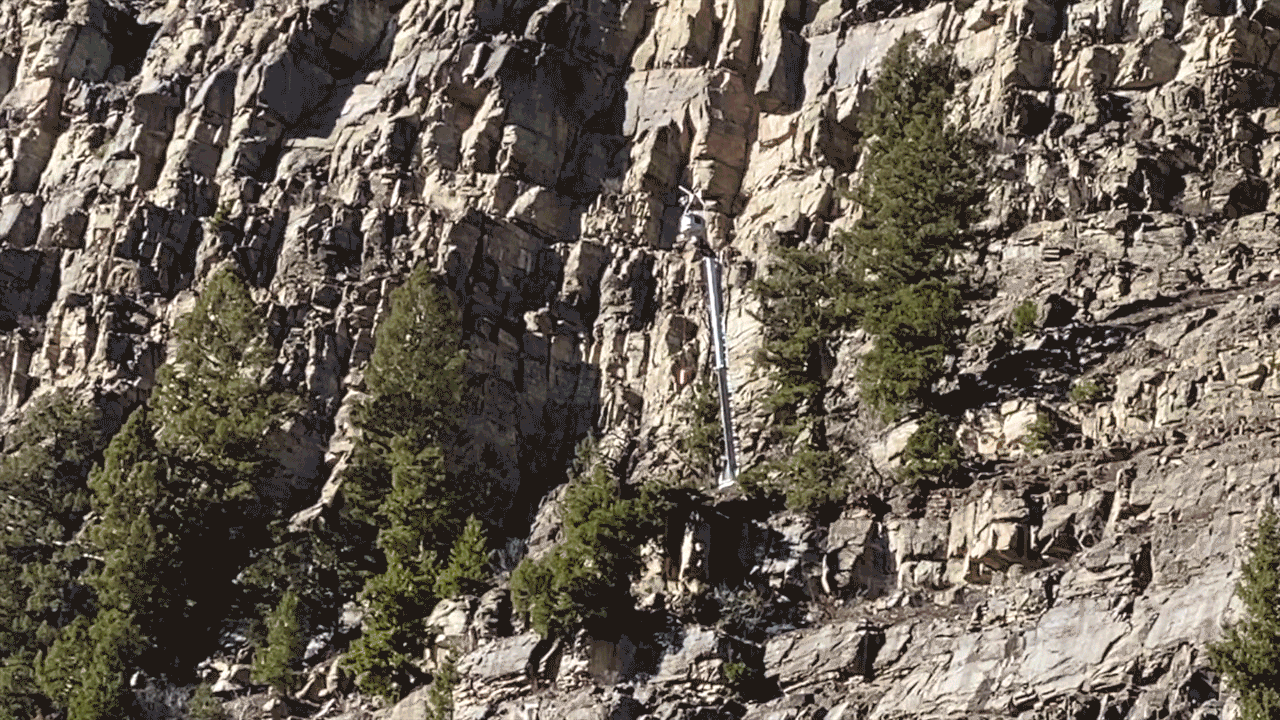
Durango's Lisa Schwantes, regional communications manager in southwest Colorado for CDOT, explained that in the summer of 2023, the department will build towers that contain explosives along some of the known slide areas on Red Mountain Pass. These towers contain gasses and ammunition, and crews can trigger an explosion from afar using a tablet or computer. A few already exist on US 160 and State Highway 145.
Avalanche mitigation crews with CDOT in southwest Colorado have other tools at their disposal to knock down a slide too, including case charges placed near the risky area or dropped from a helicopter, an "avalauncher" cannon to fire a trajectory at the slide path, or howitzer artillery guns to shoot ammunition into the slope.

Schwantes explained that just like the past few decades, avalanche experts with CAIC — "snow geeks," she said CDOT lovingly calls them — alerts CDOT when they determine that one or more chutes are carrying too much unstable snow. Some of the data supporting their decision to make that call comes directly from the CDOT crews on the road.
"Our mountain crews are in contact with them regularly, especially when the snow starts to fall," Schwantes said. "The CAIC folks — they rely upon our crews who are out battling the snow in the middle of the night, early in the morning, in the middle of the day. They want to know what the conditions are (that) crews are seeing."
The snowshed that saved crews' lives early on March 5, 1992, where snowplower Eddie Imel was killed, still remains along US 550. In 2000, a resident from Meeker wrote an opinion article for the March 12 edition of The Daily Sentinel arguing that the shed is only 15% as long as what is required for safe traveling under the East Riverside Slide.
"It's been discussed in the past and we could certainly benefit from extending that snow shed," Schwantes said when asked about it. "But at this point, it's not going to be extended."
However, other projects are in the works, she said. That includes everything from resurfacing the roadway to replacing crib walls, which support and stabilize the highway.
Today, CDOT has four or five crews working the US 550 corridor with three to five professionals on each crew, Schwantes said.
Since the CDOT-CAIC partnership began in 1992, nobody has died at the hands of an avalanche along Colorado's US 550.
That's not a record CAIC takes lightly.
"You know, we are dealing with natural hazards," Greene said. "And we pay very close attention to what's happening every single day, because there is an air of unpredictability with big weather events, and certainly with the avalanche events. But so far, the program has been quite successful."
READ MORE: Colorado Avalanche Information Center says it's seen more avalanches this year than previous years
CAIC backcountry forecaster to tackle US 550 position
Finding somebody to fill the previously open US 550 avalanche forecaster position was not quite as challenging as it may sound, Greene said.
"Typically, the people that are interested in this type of work really like being in the snow and in the mountains," he said. "So, it's not hard to convince somebody to move to an area like that. I mean, living in Ouray or Silverton for a lot of people is a dream. These are wonderful communities. They are small communities and they're away from a lot of the things that people who live in some of the bigger cities in our state enjoy, but most of the people that want to do this type of work, they are willing to make that trade-off."
Greene didn't have to look far.
Jeremy Yanko, the new hire, had been forecasting backcountry avalanches for CAIC before he took on the role. After graduating college, he worked as a patroller and guide at Silverton Mountain Ski Area, which included 15 seasons in an active avalanche program. He has been involved with EMS and search and rescue in Silverton for 12 years.

"He's also worked for ski areas and as a backcountry guide in the past, so he has a fairly long history of avalanche forecasting and actually avalanche forecasting in the San Juan Mountains of Colorado," Greene said.
Greene said Yanko was not available for interviews due to the crucial training leading into avalanche season. Yanko has stepped into the "permanent part-time position," Greene said, explaining that the position is full-time in the winter and has reduced hours in the summer.
But winter will surely be the most exciting time.
For Hogan, the countless slides he analyzed along US 550 still have a frozen grip on him, even 25 years after he left the position. Perhaps that's the case for all CAIC researchers who work in the tumultuous territory of avalanches.
"I keep my finger, my toe in," he said. "I still socialize with some of the old forecasters. And for me, it’s just a real satisfying thing to have worked for them."