


BOULDER, Colo. — A flash flood watch is now in effect for parts of the northern Front Range, foothills and mountains, especially around Grand County's burn scar areas.
The National Weather Service (NWS) out of Boulder said this watch is in effect until 10 p.m. Monday. Heavy rainfall can trigger flash flooding and debris flows around the burn scars from the Cameron Peak Fire, East Troublesome Fire, and Calwood Fire, all of which burned in 2020.
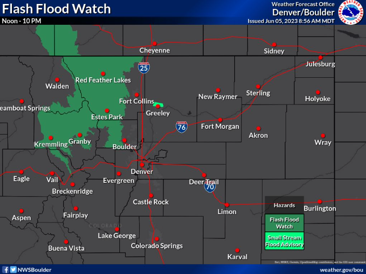
The flash flood watch also impacts Summit County, Larimer County, Jackson County and Boulder County, including Fraser, Nederland, Red Feather Lakes, Rocky Mountain National Park, Hot Sulphur Springs, Estes Park, Grand Lake and Kremmling.
The stronger thunderstorms Monday may drop up to an inch of rain in just 30 minutes, the NWS reported.
The Cameron Peak and East Troublesome burn scars are under an "elevated" risk of flash flooding Monday through Wednesday, according to the NWS. The burn scars from the Calwood Fire and Williams Fork Fire are considered to have "limited" risk of flooding Monday.
The threat will be the most prevalent from 1-6 p.m.
⚠️ Flash flood threat increasing in the recent burn areas today. Greatest threat between 1 pm and 6 pm. If you live in/near a recent burn area, have an action plan and be ready to move to higher ground should heavy rain/flooding occur. #COwx pic.twitter.com/KYIYym2I1n
— NWS Boulder (@NWSBoulder) June 5, 2023
The NWS said anybody in the affected areas should be prepared to take action in case the watch is upgraded to a flash flood warning. In a watch, conditions are favorable for flooding, but in a warning, it means flooding is imminent or currently happening.
In addition, a flood advisory is in effect until 6:30 p.m. Monday for part of northeast Colorado near and along the Cache La Poudre River in Weld County. Minor flooding is possible in low-lying areas, or places with poor drainage. Sections of the Poudre River Trail in this area may be overrun by the river.
A second flood advisory is impacting Lakewood, Centennial, Highlands Ranch, Parker and Littleton until 7:30 p.m. Monday. Another advisory for northeastern Lakewood, Arvada, Wheat Ridge, Golden, Edgewater and Mountain View will last until 7:15 p.m.
A fourth flood advisory is in effect for the Cameron Peak Fire burn scar until 5 p.m. Peterson Lake and Long Draw Road are the most likely places to experience minor flooding, the NWS reported.
Neither the watch nor the advisory are expected to cause widespread issues — they are mostly highly localized, the NWS reported.
LEARN MORE: Hourly forecast | Radars | Traffic | Weather Page | 24/7 Weather Stream
The NWS is reminding drivers, bicyclists and pedestrians to never try to navigate through flooded roads or trails. Anybody who has to shelter in place should remember to "go up, not out," NWS said. Climb to the highest point you can in whatever building you are inside.
Looking ahead, patchy fog is likely late Monday and early Tuesday morning.
On Tuesday, stormy afternoons continue and a Denver cyclone is possible.
Wondering what that is? It happens when air comes off the Palmer Divide and curls back toward the Denver area. The storms developing in the mountains run into that air from the southeast, resulting in a convergence line over the Denver metro area. Along this line, tornadoes can form as the air starts to spin. You can learn more about Denver cyclones in this explainer from Denver7 Chief Meteorologist Mike Nelson.
The NWS said this Denver cyclone may trigger storms over the urban corridor on Tuesday.
