


DENVER — Unseasonable heat in Colorado will end late Thursday, as a cold front arrives before dawn Friday, when temperatures finally drop.
The National Weather Service out of Boulder noted, "Yep, still hot" and "the forecast is nearly a copy+paste of yesterday."
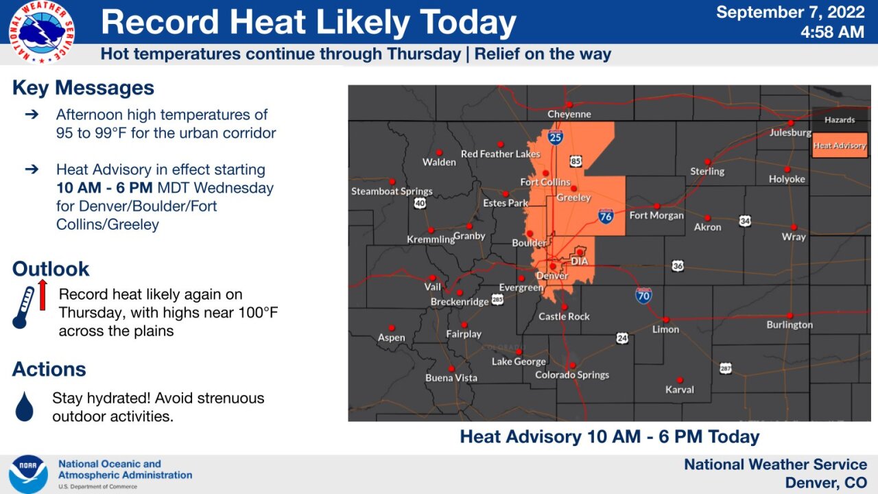
A heat advisory is in place from 10 a.m. to 8 p.m. for the Front Range from south Denver north to the Wyoming border as highs reach into the upper 90s by Thursday afternoon, according to the NWS.
Highs could reach 103 degrees at lower elevations along the Front Range, the NWS said.
The NWS forecast predicts several record-breaking temperatures:
- Denver: Forecast calls for 98 degrees, record is 95 degrees in 2013
- Fort Collins: Forecast calls for 97 degrees, record is 93 degrees in 1959
- Boulder: Forecast calls for 96 degrees, record is 93 degrees in 2013
Thursday marked Denver's 64nd day of the year at or above 90 degrees — 2022 now ranks as the third year on record with the most days at or above 90 degrees. Denver saw 73 days of this kind of heat in 2012 and 75 days in 2020. Wednesday and Thursday will push Denver to 64 days at or above 90 degrees.
The heat prompted Denver Public Schools to announce it would release students early, or cancel school altogether, for more than 30 schools on Wednesday and Thursday. This includes some schools that do not have air conditioning. Click here for that list.
Over the next couple days, smoke from intensifying wildfires in the northwest United States will drift over Colorado. But the temperatures will not be nearly as hot!
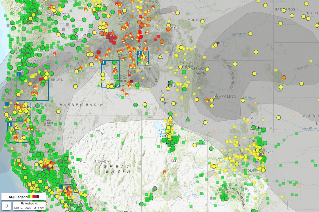
Click here for a live map showing wildfires and their smoke impacts across the country.
On Tuesday, the Colorado Department of Public Health and Environment (CDPHE) issued an ozone action day alert that will last until 4 p.m. Wednesday for the Front Range urban corridor, which includes Douglas County north to Larimer and Weld counties, including the Denver-Boulder area, Fort Collins and Greeley.
The hot, dry, and sometimes smoky conditions Wednesday may become unhealthy for sensitive people to be outside.
The NWS office out of Pueblo warned that Wednesday and Thursday are expected to be the hottest days of the week in the region. Isolated thunderstorms and showers are possible near the mountains.
On the western slope, the NWS out of Grand Junction said rainfall is also possible each day this week in the San Juan Mountains, but record heat will persist for the next several days.
More of the same kind of conditions will follow on Thursday.
The NWS said Denver may see its latest 100-degree day on Thursday — a record that was broken two years ago.
Also on Thursday, a fire weather watch will cover much of the eastern plains due to record heat, low humidity (as low as 9%), dry fuels and breezy conditions, the NWS said. Wind gusts may reach between 25 to 30 mph. The watch will begin at 10 a.m. Thursday and continue until 8 p.m., the NWS said.
A heat advisory will also affect the eastern plains on Thursday, including areas around Briggsdale, Fort Morgan, Byers, Sterling, Akron, Julesburg, and Holyoke, according to NWS. Highs may reach 105 degrees.
An ozone action day alert is in effect until Thursday at 9 a.m. for Routt, Jackson, and Grand Counties, including Steamboat Springs, Walden, and Hot Sulphur Springs. Smoke may gather in sheltered valleys, the CDPHE warned.
By Thursday evening, a series of cold fronts will arrive in Colorado, bringing much-needed relief. Friday will stay much cooler and showers are expected on Saturday, the NWS said. If Denver sees widespread drizzle that day, highs may only reach into the 50s.
The mountains around 9,000 to 10,000 feet could see some snow, but any precipitation up at those elevations look light, the NWS said.