


DENVER — As Coloradans continue to bake in the anticipated record-breaking Thursday temperatures, let’s take a look back at the stark contrast on this day in 2020.
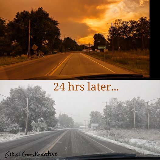
Two years ago, a fast-moving cold front began racing into Colorado the evening of Sept. 7 after temperatures climbed to the low to mid-90s earlier that day.
By the morning of Sept. 8, 2020, the Denver metro area was experiencing a mix of light rain and snow that transitioned to full snow by the evening.

Several inches of snow dropped on parts of the Front Range, with nearly a foot dumping on other parts of the state between Sept. 8 and 9.
GALLERY: A look back at the Sept. 8, 2020, Colorado snowstorm
According to the National Weather Service, Maysville recorded one of the highest amounts at 11.9 inches. The Denver International Airport topped out at 1 inch, while areas like Castle Rock, Boulder and Fort Collins saw between 2 and 6 inches.
RELATED: Here are the snow totals for Tuesday's snowstorm in Colorado
This sharp weather shift came as first responders were battling the Cameron Peak Fire, which exploded by 40,000 acres on Sept. 7, and just days after Denver recorded its first-ever triple-digit day in September. As much as 5 inches of snow fell on the northern part of the fire, with at least an inch falling on the rest of what would eventually become the state’s largest wildfire on record.
RELATED: Snow falls on Cameron Peak Fire Tuesday day after explosive growth
While Colorado won’t see quite as dramatic of a shift this time around, Thursday is expected to be the last day of the oppressive heat wave, with a cold front moving through on Friday. Snow isn’t expected, but high temperatures are expected to drop by 20 to 30 degrees down to the low 70s, with storms moving in. Saturday will be even cooler, with highs in the mid 50s to around 60 degrees and showers.
IN-DEPTH: What to expect from Colorado's weather in September
Before Coloradans can welcome the relief, expect several cities to break records for high temperatures for Sept. 8, including Denver, ironically, expected to hit a triple-degree high like in 2020.
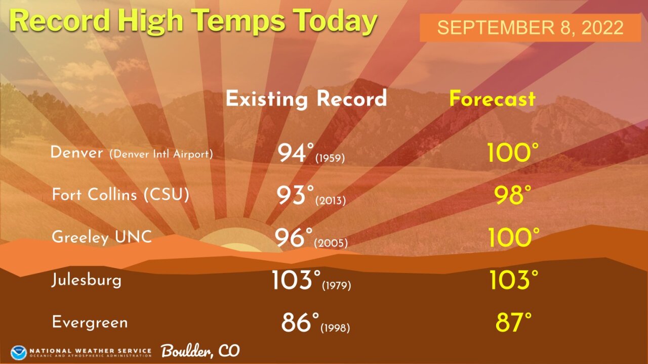
A heat advisory is in effect for parts of the Denver metro area and northeast Colorado until 8 p.m. A red flag warning is also in effect for much of the eastern half of the state as winds move in ahead of the incoming cold front. Sudden gusty winds are possible, reaching 30-50 mph.
