


UPDATE (Friday, April 29, 12:22 p.m.): Denver International Airport received 0.05 inches of rain and hail around noon Friday, which means this April will not set the new record for the driest April ever. But it will still be among the driest ever recorded.
The chance for the Denver driest April ever is over! Thunderstorms have just moved over Denver with rain and hail falling. .05" has fallen in the past 15 minutes and counting. #cowx
— NWS Boulder (@NWSBoulder) April 29, 2022
Denver is poised to see its driest April in 150 years this month and drought continues to worsen, as only one one-hundredth of an inch of precipitation has fallen so far and there is only a slight chance of rain through the end of the month.
Denver has also only seen a trace of snow this month officially, which would put this April tied for fourth for the least snowy Aprils on record behind 1992, 1943 and 1930, when no snow fell.
The 0.01 inches of precipitation, if it stands, would mark the driest April since the National Weather Service in Boulder began keeping records in 1872. In 1963, 0.03 inches fell in April, and in 1878, just 0.05 inches of precipitation fell. This century, 2002 was the driest April so far, when only 0.23 inches of precipitation fell.
Preliminary April 2022 Precipitation Totals & Records #COwx pic.twitter.com/Y0axbvbibt
— NWS Boulder (@NWSBoulder) April 28, 2022
Denver averages 1.53 inches of precipitation in April, according to the NWS. But it can also see plenty of precipitation during the month, as the top 20 wettest Aprils on record all saw more than 3 inches of precipitation – including a record 8.24 inches in 1900.
Denver has also seen some very snowy Aprils, which is typically the second-snowiest month for the city. The snowiest April ever was 1933, when 33.8 inches of snow fell.
Since 2000, Denver has averaged 1.56 inches of precipitation in April – the wettest being 2009 (3.22 inches) and the driest being 2002 (0.23 inches). Last April, Denver saw more than 2 inches of precipitation for the month.
And since 2006, Denver averages 5.3 inches of snowfall in April – the least falling in 2006 (0.3 inches) and the most falling in 2013 (20.4 inches) over that period.
Temperatures so far this April have been, on average, nearly exactly at normal levels in Denver – with the average maximum temperature slightly above normal and the average minimum temperature slightly below normal.
The dry April has now put Denver behind normal levels precipitation-wise for this time of the year despite a wet beginning to the year. And it has made drought conditions worse – especially in the Denver metro area and across eastern Colorado.
Severe drought crept back into northeast Denver, most of Adams County, eastern Arapahoe County, and most of the eastern plains over the past week – areas that were mostly considered to be experiencing only moderate drought just a week ago, according to the U.S. Drought Monitor.
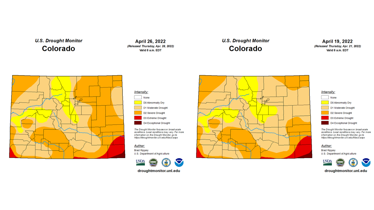
And moderate drought overtook abnormally dry areas in western Elbert County and eastern Douglas County.
As of this week, 89% of Colorado is experiencing moderate or worse drought conditions. Forty-eight percent of the state is in severe or worse drought, while 4% of the state, mostly along the southern border, is experiencing extreme or exceptional drought, according to the U.S. Drought Monitor.
The authors of this week’s drought report said 47% of Colorado’s winter wheat was rated in very poor to poor condition – the largest share among the major wheat-producing states, followed by Kansas at 36% of its crop.

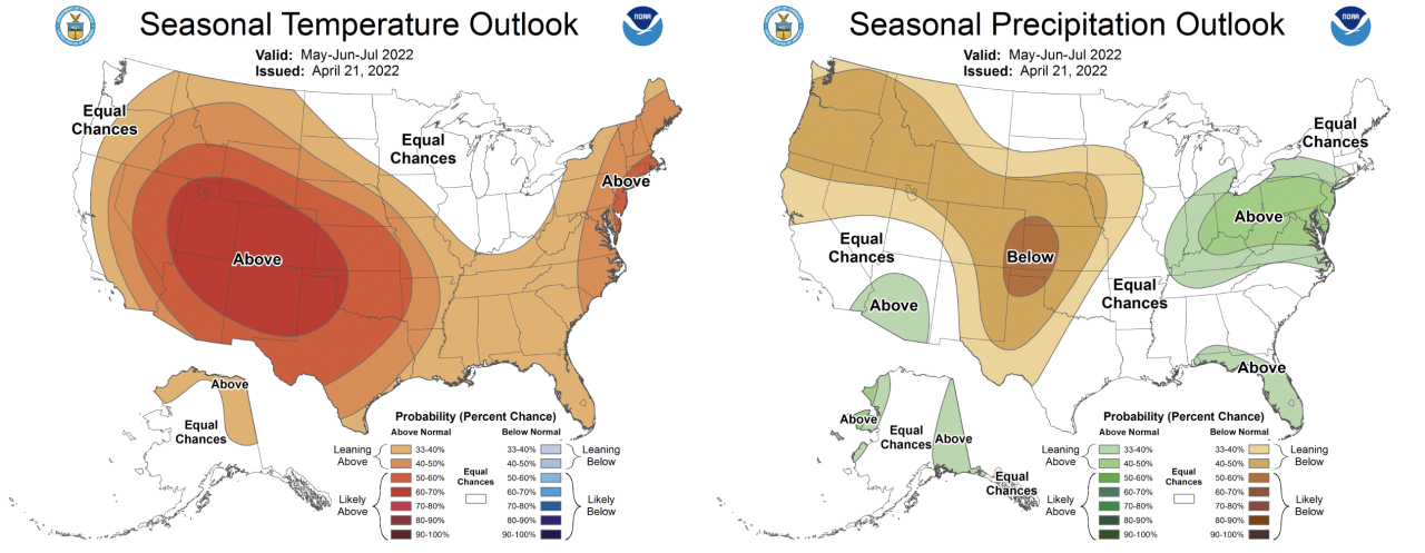
And the Climate Prediction Center’s seasonal drought outlook, issued last week, predicts drought will persist across the areas in Colorado already seeing it, and continue to develop in areas that are currently only abnormally dry. The same can be said for nearly all of the West except for the Pacific Northwest and southern Arizona.
The Climate Prediction Center is forecasting above-average temperatures and below-average precipitation for May, which are only expected to worsen in June and July.
The dry weather has also been paired with gusty winds for much of the month. There have been 15 red flag watches or warnings issued for Denver so far this month by the National Weather Service, according to the Iowa State University Iowa Environmental Mesonet. But on the plains near Burlington, there have been 21 this month so far.
Red flag warnings will again be in effect for critical fire danger for most of southeastern Colorado on Friday for 20-30 mph winds that could gust up to 50 mph and relative humidity levels as low as 7%, according to the NWS. Dozens of wildfires have burned across the state this month. Winds in the metro area are expected to be in the 20-30 mph range as well.
MORE: 'Critical to extreme' fire weather will linger across southern Colorado next few days
The Division of State Fire Prevention and Control said last week it is predicting an earlier-than-normal beginning to what they are now calling the “core fire season” – officials now know wildfire is possible year-round – and above-normal fire behavior during that core part of the season.
“I feel good about how prepared we are, but I know we’re going to have some tough days, some bad days,” DFPC Director Mike Morgan said last week.
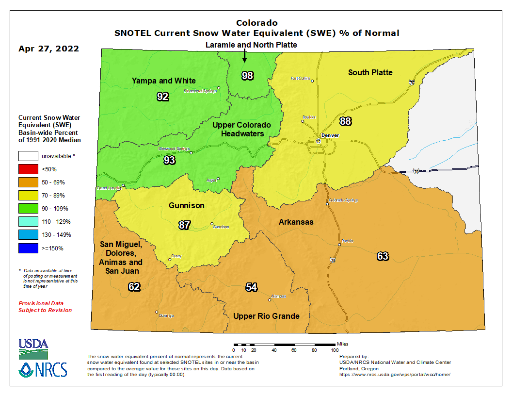
Statewide snowpack was 82% of median levels as of Thursday, with the northern river basins still near median levels. But the three southernmost basins – the San Miguel, Dolores, Animas and San Juan; Upper Rio Grande; and Arkansas basins were all between 54% and 63% of median levels.
Sunday – the first day of May – could bring some rain and storms to Denver and eastern Colorado later on in the evening and into Monday morning, with another chance of rain midweek.