
Chaffee County’s slogan is “This is Colorado.” And the hike to Browns Creek Falls showcases a lot of what the Colorado outdoors has to offer, including views of two 14ers (peaks over 14,000 feet), a dense forest, a scenic meadow, aspen trees, a river crossing and a waterfall.
The hike starts about 17 miles south of Buena Vista.
The trailhead has bathrooms and signs. Three signs talk about the Boreal toad and ask visitors to stay away from them and keep their dogs away from them. The signs explain that the Boreal toad is Colorado’s only alpine toad and it’s endangered.
There’s only one trail from the trailhead — it goes to the Colorado Trail, Browns Creek Falls and Browns Lake.

Head up the dirt path, passing through a gate about 0.2 miles from the parking lot. Then the trail cuts across a cliff side. While you’ll spend a lot of your time watching your feet on the rocky trail, look up occasionally for the mountain views.
Reviewers on AllTrails often talk about the first mile of the trail being steep. It is. You’ll climb about 500 feet in elevation in the first mile. After that, there’s still 400 feet of gain, but it’s spread out over the next two miles.
At the halfway point, there’s a sign for the Colorado Trail, which is a 500-mile trail from southeast Denver to Durango. You’ll be walking on that trail for about a quarter mile until it turns a different direction.

Keep following the main trail as it heads through the forest. There’s a big meadow at about 2.5 miles, but you’re quickly back in the trees.
When the trail comes to a river crossing, don’t go that way. Turn right and follow the trail to a log bridge across the water.
At this point, you’re getting close to the falls.
There’s one more log bridge river crossing, then you’ll pass the hitch rack for horses. When you come to a sign, hikers going to the lake turn right, but hikers going to the falls turn left.
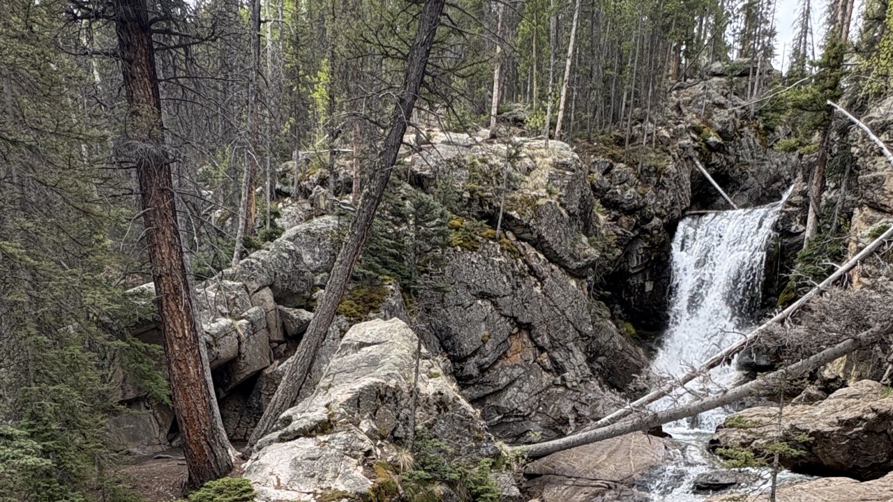
Just a short distance from here, you’ll find yourself next to a beautiful two-tired waterfall. We’ve sat on the rocks here and enjoyed lunch many times. If you’re adventurous, you can cross the river or scramble next to the river to get a closer view of the upper cascade or lower one. Just stay safe!

When you’re done snacking and exploring, return the way you came.
On the way back, about a half mile before the trailhead, make sure you stop looking at your feet for a minute and see the view of the valley below.
Details: The hike to Browns Creek Falls is six miles roundtrip with about 900 feet of elevation gain.
Directions: Take Highway 285 south of Buena Vista and Nathrop. Turn right on County Road 270, which turns into 272. You will get to a spot where you can continue straight on 274, or turn left to stay on 272. Stay on that road, headed south, for about 1.6 miles to the trailhead.
If you have any questions, or hike suggestions, email me at HikingDebbie@gmail.com and find more great hikes by following me on Facebook at Facebook.com/DenverHikingExaminer.